The BEETLE least-cost focal species approach negates the need to carry out a vast number of individual species analyses. The selection of the habitats to be modelled, and the species used to inform the analysis, were identified through a series of expert stakeholder workshops. The outputs can support the planning process, help prioritise conservation effort, prevent further fragmentation of biodiversity and aid connectivity of semi natural habitats.The BEETLE model analysis has been well referenced (Watts et al., 2005) and used in a variety of projects such as developing forest habitat networks across Scotland. The application of IHNs is the first time that the multiple habitat network approach has been used to solicit planning and development programmes in key areas.More informationComplete metadata on SpatialData.gov.scot
This submission contains mesh information, nodal coordinates, connectivity data, and list of query points for the build FEM configuration.
The BEETLE least-cost focal species approach negates the need to carry out a vast number of individual species analyses. The selection of the habitats to be modelled, and the species used to inform the analysis, were identified through a series of expert stakeholder workshops. The outputs can support the planning process, help prioritise conservation effort, prevent further fragmentation of biodiversity and aid connectivity of semi natural habitats.The BEETLE model analysis has been well referenced (Watts et al., 2005) and used in a variety of projects such as developing forest habitat networks across Scotland. The application of IHNs is the first time that the multiple habitat network approach has been used to solicit planning and development programmes in key areas.More informationComplete metadata on SpatialData.gov.scot
The BEETLE least-cost focal species approach negates the need to carry out a vast number of individual species analyses. The selection of the habitats to be modelled, and the species used to inform the analysis, were identified through a series of expert stakeholder workshops. The outputs can support the planning process, help prioritise conservation effort, prevent further fragmentation of biodiversity and aid connectivity of semi natural habitats.The BEETLE model analysis has been well referenced (Watts et al., 2005) and used in a variety of projects such as developing forest habitat networks across Scotland. The application of IHNs is the first time that the multiple habitat network approach has been used to solicit planning and development programmes in key areas.More informationComplete metadata on SpatialData.gov.scot
The BEETLE least-cost focal species approach negates the need to carry out a vast number of individual species analyses. The selection of the habitats to be modelled, and the species used to inform the analysis, were identified through a series of expert stakeholder workshops. The outputs can support the planning process, help prioritise conservation effort, prevent further fragmentation of biodiversity and aid connectivity of semi natural habitats.The BEETLE model analysis has been well referenced (Watts et al., 2005) and used in a variety of projects such as developing forest habitat networks across Scotland. The application of IHNs is the first time that the multiple habitat network approach has been used to solicit planning and development programmes in key areas.More informationComplete metadata on SpatialData.gov.scot
The BEETLE least-cost focal species approach negates the need to carry out a vast number of individual species analyses. The selection of the habitats to be modelled, and the species used to inform the analysis, were identified through a series of expert stakeholder workshops. The outputs can support the planning process, help prioritise conservation effort, prevent further fragmentation of biodiversity and aid connectivity of semi natural habitats.The BEETLE model analysis has been well referenced (Watts et al., 2005) and used in a variety of projects such as developing forest habitat networks across Scotland. The application of IHNs is the first time that the multiple habitat network approach has been used to solicit planning and development programmes in key areas.More informationComplete metadata on SpatialData.gov.scot
The BEETLE least-cost focal species approach negates the need to carry out a vast number of individual species analyses. The selection of the habitats to be modelled, and the species used to inform the analysis, were identified through a series of expert stakeholder workshops. The outputs can support the planning process, help prioritise conservation effort, prevent further fragmentation of biodiversity and aid connectivity of semi natural habitats.The BEETLE model analysis has been well referenced (Watts et al., 2005) and used in a variety of projects such as developing forest habitat networks across Scotland. The application of IHNs is the first time that the multiple habitat network approach has been used to solicit planning and development programmes in key areas.More informationComplete metadata on SpatialData.gov.scot
The BEETLE least-cost focal species approach negates the need to carry out a vast number of individual species analyses. The selection of the habitats to be modelled, and the species used to inform the analysis, were identified through a series of expert stakeholder workshops. The outputs can support the planning process, help prioritise conservation effort, prevent further fragmentation of biodiversity and aid connectivity of semi natural habitats.The BEETLE model analysis has been well referenced (Watts et al., 2005) and used in a variety of projects such as developing forest habitat networks across Scotland. The application of IHNs is the first time that the multiple habitat network approach has been used to solicit planning and development programmes in key areas.More informationComplete metadata on SpatialData.gov.scot
PTAL is a measure of connectivity by public transport, which has been used in various planning processes for many years. For any selected place, PTAL suggests how well the place is connected to public transport services. It does not cover trips by car. The PTAL model calculates December 2019 public transport accessibility for every 2016 ABS Mesh Block in New South Wales. The TfNSW PTAL model is based on the Transport for London (TfL) PTAL and was adapted for TfNSW in collaboration with the Spatial Information Science team at the Department of Earth and Environmental Sciences, Macquarie University. The [Assessing transport connectivity in London](http://content.tfl.gov.uk/connectivity-assessment-guide.pdf) explains what PTAL is, how to understand the data and more. PTAL values are simple. They range from zero to six, where the highest value represents the best connectivity. A location will have a higher PTAL if: \* It is at a short walking distance to the nearest stations or stops \* Waiting times at the nearest stations or stops are short \* More services pass at the nearest stations or stops \* There are major rail stations nearby \* Any combination of all the above. Please read the PTAL documentation for more information. The format of the data is Arcgis geodatabase. **Images below show an example of what the data looks like at 8:00am (first image) and 1:00am (second image)**. 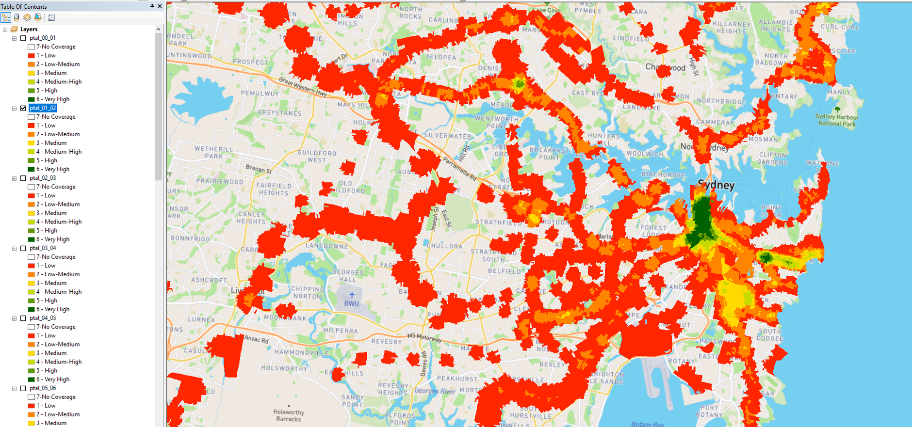
Water stable isotope data (hydrogen and oxygen isotopes of H2O) from wetlands and streams within the Pipestem Creek watershed. This data was collected over two open water seasons (May-September): 2014 and 2015. This dataset is associated with the following publication: Brooks, J.R., D. Mushet, M. Vanderhoof, S. Leibowitz, J. Christensen, B. Neff, D. Rosenberry, W. Rugh, and L. Alexander. Estimating wetland connectivity to streams in the Prairie Pothole Region: an isotopic and remote sensing approach. WATER RESOURCES RESEARCH. American Geophysical Union, Washington, DC, USA, 54(2): 995-977, (2018).
The BEETLE least-cost focal species approach negates the need to carry out a vast number of individual species analyses. The selection of the habitats to be modelled, and the species used to inform the analysis, were identified through a series of expert stakeholder workshops. The outputs can support the planning process, help prioritise conservation effort, prevent further fragmentation of biodiversity and aid connectivity of semi natural habitats.The BEETLE model analysis has been well referenced (Watts et al., 2005) and used in a variety of projects such as developing forest habitat networks across Scotland. The application of IHNs is the first time that the multiple habitat network approach has been used to solicit planning and development programmes in key areas.More informationComplete metadata on SpatialData.gov.scot
The BEETLE least-cost focal species approach negates the need to carry out a vast number of individual species analyses. The selection of the habitats to be modelled, and the species used to inform the analysis, were identified through a series of expert stakeholder workshops. The outputs can support the planning process, help prioritise conservation effort, prevent further fragmentation of biodiversity and aid connectivity of semi natural habitats.The BEETLE model analysis has been well referenced (Watts et al., 2005) and used in a variety of projects such as developing forest habitat networks across Scotland. The application of IHNs is the first time that the multiple habitat network approach has been used to solicit planning and development programmes in key areas.More informationComplete metadata on SpatialData.gov.scot