This dataset provides **Bus Guides** for 13 Metro Stations along the Sydney Metro North West Line, including 8 new metro stations along the Chatswood to Sydenham extension due to commence August 2024. Each guide displays a table with all the Bus routes including the destination description and stand section and a Bus Map.
The Car Park API provides real time and historical occupancy of selected car parks. This API provides the occupancy for Transport Park&Ride car parks. Transport Park&Ride is designed to free-up more spaces at commuter car parks for those who want to travel on public transport. The data feed contains the parking occupancy information by type in real time. The Sydney Metro stations for Tallawong, Bella Vista, Hills Showground, Cherrybrook and Kellyville are reporting real time occupancy levels. It is intended other car park occupancy data will be enabled via this API in the future. Click [here](https://transportnsw.info/travel-info/ways-to-get-around/drive/parking/transport-parkride-car-parks) for more information on Transport Park&Ride.
This dataset provides Local Area Guides for 13 Metro Stations along the Sydney's Metro North West Line. Each guide displays a local area map with an approximate 600m radius around the Metro station capturing bus stands, facilities, tickets and destinations. **Note:** * 12 new WCAG 2.0 compliant wayfinding maps have been added for the Chatswood to Sydenham extension, including 6 new station & local area maps and 6 existing station & local area maps in July 2024. * The M1 route, Metro North West & Bankstown Line will commence operations Sunday 4 August 2024. For an interactive guide to each of these Metro stations visit [https://transportnsw.info/travel-info/ways-to-get-around/metro#/](https://transportnsw.info/travel-info/ways-to-get-around/metro#/).
Contains the latest Metro / Outer Metro Bus contract boundaries in a shapefile format This dataset is the shapefile equivalent to the pdf maps in the [Opal Trips - Bus](https://opendata.transport.nsw.gov.au/dataset/opal-trips-bus) dataset
This dataset provides WCAG 2.0 compliant wayfinding maps for 13 Metro Stations along the Metro North West Line, including 8 new metro stations and 5 upgraded stations. Metro services are high-frequency, driverless trains, which can quickly take you between stations operating every 4 minutes in peak times. Each map displays the transport connections, customer assistance available, facilities available, tap on / tap off points, and lift / escalator locations. The line is being extended into the Sydney CBD and beyond, in 2024. **Note:** * 13 new WCAG 2.0 compliant wayfinding maps have been added for the Chatswood to Sydenham extension, including 6 new station & local area maps and 7 existing station & local area maps in July 2024. * The M1 route, Metro North West & Bankstown Line will commence operations August 2024.
This dataset contains a consolidated view of Official Utilisation figures across all transport modes (train, metro, bus, ferry and light rail). Opal daily tap-on/tap-off data is aggregated to a total monthly figure representing the estimated number of trips across all transport modes.
This dataset contains Official Bus Utilisation figures. Opal tap-on/tap-off data (representing an individual boarding and alighting a bus) is aggregated to a total monthly figure representing the estimated number of trips. \*\*Caution \*\* 1. School Student travel using concessional Opal cards is included. However this may be underrepresented, due to inconsistent tap-on/tap-off behaviour by students 2. Magnetic Stripe Ticketing (MST – paper tickets) data was also available in July 2016. MST patronage data for July is available [here](https://www.transport.nsw.gov.au/newsroom-and-events/reports-and-publications/magnetic-stripe-ticketing-mst-patronage-data-july-2016) 3. Opal data may be subject to minor revision for the two months following upload 4. Data is static at a point in time, and may not match other reports that are real time 5. All non-Opal travel is excluded, for example transport concession entitlement cards, integrated ticketing for major events, and fare non-compliance 6. An Opal Trip is defined as a tap-on/tap-off pair (including where only a single tap-on or tap-off is recorded) 7. 'Other' group under bus contract includes NightRide and Unallocated. 8. Keolis Downer Hunter took over the Newcastle Bus franchise from Newcastle Buses (State Transit Authority) effective 1 July 2017. The contract area NISC1 reflects this and Keolis Downer Hunter figures for Jul 2017 onwards are included as part of Private Bus Operator numbers. From January 2018 NISC1 includes non-Opal categories of On Demand and Other. The category ‘Other’ includes: Fare Free Zone, Integrated Ticketing, Free Travel Passes, Route 110 Newcastle City Loop, Park and Ride, and Special Events. 9. Transit Systems West took over the Sydney Metropolitan Bus Service Contract 6 from Sydney Buses (State Transit Authority) effective 1 July 2018. The contract area SBSC Contract 6 reflects this and Transit Systems West figures for Jul 2018 onwards are included as part of Private Bus Operator numbers. 10. Figures in Jul 2017 for Newcastle Buses reflect services operated by STA which completed post-midnight 30 June 2017. 11. NightRide services are included in Sydney Metropolitan Bus Services Contract (SMBSC) areas from 1 March 2018 onwards. 12. Keolis Downer Northern Beaches took over the Sydney Metropolitan Bus Service Contract 8 from Sydney Buses (State Transit Authority) effective 31 October 2021. The contract area Greater Sydney Bus Contract 8 (GSBC008) reflects this and Keolis Downer Northern Beaches figures for Nov 2021 onwards are included as part of Private Bus Operator numbers. 13. Busways North West took over the Sydney Metropolitan Bus Service Contract 7 from Sydney Buses (State Transit Authority) effective 9 January 2022. The contract area Greater Sydney Bus Contract 7 (GSBC007) reflects this and Busways North West figures for Jan 2022 onwards are included as part of Private Bus Operator numbers. 14. Transdev John Holland took over the Sydney Metropolitan Bus Service Contract 9 from Sydney Buses (State Transit Authority) effective 3 April 2022. The contract area Greater Sydney Bus Contract 9 (GSBC009) reflects this and Transdev John Holland figures for April 2022 onwards are included as part of the Private Bus Operator numbers. 15. CDC NSW took over Sydney Metropolitan Bus Service Contracts 12 and 14 from Transdev and Forest Coaches, effective 21 May 2023. The contract area Greater Sydney Bus Contract 14 (GSBC014) reflects this and CDC NSW figures after 21 May 2023 are included as part of the Private Bus Operator numbers. 16. U-Go Mobility took over Sydney Metropolitan Bus Service Contracts 05 and 10 from Punchbowl and Transdev NSW, effective 1 July 2023. The contract area Greater Sydney Bus Contract 10 (GSBC010) reflects this and U-Go MObility figures after July 2023 are included as part of the Private Bus Operator numbers. 17. Transit Systems NSW took over Sydney Metropolitan Bus Service Contracts 3 and 13 from Transit Systems and Transdev NSW, effective 6 August 2023. The contract area Greater Sydney Bus Contract 3 (GSBC003) reflects this and Transit Systems NSW figures after 6 August 2023 are included as part of the Private Bus Operator numbers. 18. Transit Systems NSW SW took over Sydney Metropolitan Bus Service Contracts 2 and 15 from Interline and Busabout, effective 8 October 2023. The contract area Greater Sydney Bus Contract 2 (GSBC002) reflects this and Transit Systems NSW SW figures after 8 October 2023 are included as part of the Private Bus Operator numbers. 19. Busways R1 took over Sydney Metropolitan Bus Service Contracts 1, effective 10 December 2023. The contract area Greater Sydney Bus Contract 1 (GSBC001) reflects this and Busways R1 figures after 10 December 2023 are included as part of the Private Bus Operator numbers. 20. CDC NSW R4 took over Sydney Metropolitan Bus Service Contracts 4, effective 10 March 2024. The contract area Greater Sydney Bus Contract 4 (GSBC004) reflects this and CDC NSW R4 figures after 10 March 2024 are included as part of the Private Bus Operator numbers. 21. Redbus CDC NSW took over Outer Sydney Metropolitan Bus Service Contract 7, effective 6 July 2024. The contract area Outer Metro Bus Services Contract 7 (OMBSC007) reflects this and Redbus CDC NSW figures after 6 July 2024 are included as part of the Private Bus Operator numbers. 22. Busways OMR6 took over Outer Sydney Metropolitan Bus Service Contract 6, effective 28 July 2024. The contract area Outer Metro Bus Services Contract 6 (OMBSC006) reflects this and Busways OMR6 figures after 28 July 2024 are included as part of the Private Bus Operator numbers. You can find the bus contract boundaries in shapefile format in the [Metro / Outer Metro Bus Contract boundaries](https://opendata.transport.nsw.gov.au/dataset/metro-outer-metro-bus-contract-boundaries) dataset
This dataset contains Official Train and Metro Utilisation figures. Opal tap-on/tap-off data (representing an individual entering & exiting a station), is allocated to a line and aggregated to a monthly figure for the estimated number of trips. Notes: (1) The timetable change on 26 November 2017 results in new line definitions and patronage splits by line for the period 26-30 November and all subsequent months. (2) A more accurate methodology for assigning trips to train line and operator has been applied to patronage from July 2017 onwards resulting in changes a revision to July – November 2017 patronage previously reported. **Caution** 1. School Student travel using concessional Opal cards is included. However this may be underrepresented, due to inconsistent tap-on/tap-off behaviour by students 2. Magnetic Stripe Ticketing (MST – paper tickets) data was also available in July 2016. MST patronage data for July is available [here](http://www.bts.nsw.gov.au/ArticleDocuments/233/Jul-16_MST_patronage_all_modes.xlsx.aspx) 3. Opal data may be subject to minor revision for the two months following upload 4. Data is static at a point in time, and may not match other reports that are real time 5. All non-Opal travel is excluded, for example transport concession entitlement cards, integrated ticketing for major events, and fare non-compliance 6. An Opal Trip is defined as a tap-on/tap-off pair (including where only a single tap-on or tap-off is recorded) 7. The timetable change on 26 November 2017 results in new line definitions with new patronage splits. This change makes patronage comparisons by line inconsistent before and after this date. The splits by line will be continually updated each month to adjust for changes in commuter behaviour in response to the change in timetable. 8. Historical data may change as new Opal data and patronage line splits becomes available for reporting. 9. Station Link, a high frequency bus service temporarily replaces train services for the closure of Macquarie University, Macquarie Park and North Ryde train stations while upgrading to Sydney Metro Northwest standards. Effective from 30th September 2018 for approximately 7 months. 10. Sydney Metro North West commenced operations May 2019.
Stop time updates for active trips, replacement vehicles, and changed stopping patterns in GTFS-realtime format for Buses, Ferries, Light Rail, Trains, Metro and Regional Bus Services (our regional services are at times referenced as "TCB" - Transport Connected Bus). An up to date list of all TCB services can be found [on the forum](https://opendataforum.transport.nsw.gov.au/t/new-real-time-regional-bus-data-is-now-available/2060).
Stop time updates for active trips, replacement vehicles, and changed stopping patterns in GTFS-realtime format for Metro and Sydney Trains.
Current vehicle positions in GTFS-realtime format for Buses, Ferries, Light Rail, Trains, Metro and Regional Bus Services (our regional services are at times referenced as "TCB" - Transport Connected Bus). An up to date list of all TCB services can be found [on the forum](https://opendataforum.transport.nsw.gov.au/t/new-real-time-regional-bus-data-is-now-available/2060).
Current vehicle positions in GTFS-realtime format for Metro and Sydney Trains.
Static timetables, stop locations, pathways for trains, and route shape information in GTFS format for operators that support realtime. Covers Buses, Ferries, Light Rail, Trains, Metro and Regional Bus Services (our regional services are at times referenced as "TCB" - Transport Connected Bus). An up to date list of all TCB services can be found [on the forum](https://opendataforum.transport.nsw.gov.au/t/new-real-time-regional-bus-data-is-now-available/2060).
Static timetables, stop locations, pathways for trains, and route shape information in GTFS format for operators that support realtime.
This dataset provides an indicator of historic rail occupancy for individual rail services from July 2019. Data included in ROAM - Rail Opal Assignment Model - includes Sydney Trains (T1 - T9) and Metro (Metro North West line) services. Note: With the introduction of the new City and Southwest Metro line, Transport is moving to a new Opal Allocation Model to handle the complexity that these new services will bring. The legacy Rail Opal Allocation Model (ROAM) data will be replaced with a new Near Real Time (NRT) ROAM from May 2024.
The rural-urban commuting area codes (RUCA) classify U.S. census tracts using measures of urbanization, population density, and daily commuting from the decennial census. The most recent RUCA codes are based on data from the 2000 decennial census. The classification contains two levels. Whole numbers (1-10) delineate metropolitan, micropolitan, small town, and rural commuting areas based on the size and direction of the primary (largest) commuting flows. These 10 codes are further subdivided to permit stricter or looser delimitation of commuting areas, based on secondary (second largest) commuting flows. The approach errs in the direction of more codes, providing flexibility in combining levels to meet varying definitional needs and preferences. The 1990 codes are similarly defined. However, the Census Bureau's methods of defining urban cores and clusters changed between the two censuses. And, census tracts changed in number and shapes. The 2000 rural-urban commuting codes are not directly comparable with the 1990 codes because of these differences. An update of the Rural-Urban Commuting Area Codes is planned for late 2013.
The 2013 Rural-Urban Continuum Codes form a classification scheme that distinguishes metropolitan counties by the population size of their metro area, and nonmetropolitan counties by degree of urbanization and adjacency to a metro area. The official Office of Management and Budget (OMB) metro and nonmetro categories have been subdivided into three metro and six nonmetro categories. Each county in the U.S. is assigned one of the 9 codes. This scheme allows researchers to break county data into finer residential groups, beyond metro and nonmetro, particularly for the analysis of trends in nonmetro areas that are related to population density and metro influence. The Rural-Urban Continuum Codes were originally developed in 1974. They have been updated each decennial since (1983, 1993, 2003, 2013), and slightly revised in 1988. Note that the 2013 Rural-Urban Continuum Codes are not directly comparable with the codes prior to 2000 because of the new methodology used in developing the 2000 metropolitan areas. See the Documentation for details and a map of the codes. An update of the Rural-Urban Continuum Codes is planned for mid-2023.
State fact sheets provide information on population, income, education, employment, federal funds, organic agriculture, farm characteristics, farm financial indicators, top commodities, and exports, for each State in the United States. Links to county-level data are included when available.
The NSW Taxi Council is the peak body for the NSW Taxi Industry. It represents taxi networks, owners and operators. This dataset includes location points of the Taxi Ranks in the Sydney Metro area including 15 of the 23 Secure Taxi Ranks. Secure taxi ranks operate late on Friday and Saturday nights in busy locations across NSW. Security guards are on duty to help ensure a safe environment for both customers and drivers. The dataset is as at 31/10/2018, and includes decommissioned Taxi Ranks due to the implementation of the L2 and L3 Light Rail infrastructure and various Pop Up Cycleways, and is missing newly implemented Secure taxi ranks.
The official Transport for NSW trip planning widget is available to display on your own website. Your customers can plan their own trip and be directed to transportnsw.info. To see this widget's Terms of Use please click [here](/trip-planning-widget-terms-use).
Thirty Minute City and Metro Strategic Centre Catchments is a foundation of the [Future Transport Strategy](https://future.transport.nsw.gov.au/future-transport-strategy/greater-sydney-network). Thirty Minute City establishes a metropolitan transport network which reinforces the metropolis of three cities, particularly the delivery of a 30-minute city where most residents in each city can access their metropolitan centre or cluster within 30 minutes by public transport. Metro Strategic Centre Catchments develops a network of 34 strategic centres with jobs, goods and services supported by a public transport, walking and cycling network. This would provide residents with a 30-minute public transport service to their nearest strategic centre seven days a week. The image below shows the thirty minute city catchments to the different strategic centre catchments. 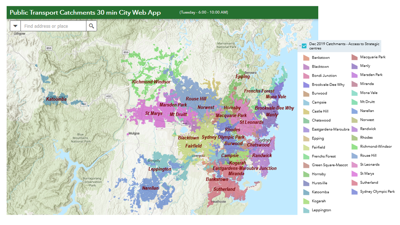 The Thirty Minute City and Metro Strategic Centre Catchments Document provides you with detailed information regards the background of this initiative and the datasets used.
Counts of train and metro station entries and exits, including monthly data, and 'typical day' samples. Note: Sydney Metro North West commenced operations May 2019.
The 2013 Urban Influence Codes form a classification scheme that distinguishes metropolitan counties by population size of their metro area, and nonmetropolitan counties by size of the largest city or town and proximity to metro and micropolitan areas. The standard Office of Management and Budget (OMB) metro and nonmetro categories have been subdivided into two metro and 10 nonmetro categories, resulting in a 12-part county classification. This scheme was originally developed in 1993. This scheme allows researchers to break county data into finer residential groups, beyond metro and nonmetro, particularly for the analysis of trends in nonmetro areas that are related to population density and metro influence. An update of the Urban Influence Codes is planned for mid-2023.