Thirty Minute City and Metro Strategic Centre Catchments is a foundation of the [Future Transport Strategy](https://future.transport.nsw.gov.au/future-transport-strategy/greater-sydney-network). Thirty Minute City establishes a metropolitan transport network which reinforces the metropolis of three cities, particularly the delivery of a 30-minute city where most residents in each city can access their metropolitan centre or cluster within 30 minutes by public transport. Metro Strategic Centre Catchments develops a network of 34 strategic centres with jobs, goods and services supported by a public transport, walking and cycling network. This would provide residents with a 30-minute public transport service to their nearest strategic centre seven days a week. The image below shows the thirty minute city catchments to the different strategic centre catchments. 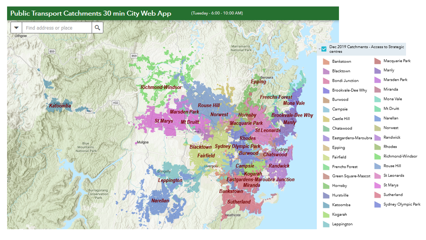 The Thirty Minute City and Metro Strategic Centre Catchments Document provides you with detailed information regards the background of this initiative and the datasets used.
The Underserved Areas File establishes underserved area designations for census tracts in Metropolitan Statistical Areas (MSAs), nonmetropolitan parts of states and Federal and State American Indian Reservations and tribal and individual trust lands. The following are the definitions of underserved geographical areas based on HUDs housing goals regulations at 24 CFR Section 81.2. a. Central Cities and Other Parts of Metropolitan Areas (i) A census tract with median income at or below 120 percent of the median income of the metropolitan area (MSA) and a minority population of 30 percent or greater; or (ii) A census tract with median income at or below 90 percent of median income of the MSA. b. Nonmetropolitan Areas (i) A census tract with median income at or below 120 percent of the greater of the State nonmetropolitan median income or the nationwide nonmetropolitan median income and a minority population of 30 percent or greater; or (ii) A census tract with median income at or below 95 percent of the greater of the State nonmetropolitan median income or the nationwide nonmetropolitan median income. c. Tribal Lands in Metropolitan Areas (i) A Federal or State American Indian reservation or tribal or individual trust land with a median income at or below 120 percent of the median income of the MSA and a minority population of 30 percent or greater; or (ii) A Federal or State American Indian reservation or tribal or individual trust land with a median income at or below 90 percent of median income of the MSA. d. Tribal Lands in Nonmetropolitan Areas (i) A Federal or State American Indian reservation or tribal or individual trust land with a median income at or below 120 percent of the greater of the state nonmetropolitan median income or the nationwide nonmetropolitan median income and a minority population of 30 percent or greater; or (ii) A Federal or State American Indian reservation or tribal or individual trust land with a median income at or below 95 percent of the greater of the state nonmetropolitan median income or the nationwide nonmetropolitan median income. e. Tribal Lands that Cross Metropolitan / Nonmetropolitan Area and/or State Boundaries For certain Federal or State American Indian reservations or tribal or individual trust lands, the tribal area crosses an MSA or state boundary. In these cases, the median incomes of the MSA or MSAs, the nonmetropolitan area of the state or states, or the nationwide nonmetropolitan area that applies to the tract containing the tribal area determines whether the part of the Federal or State American Indian reservation or tribal or individual trust land is underserved. METHODOLOGY: Whether a tract has 30 percent or more minority population is determined by rounding 30 percent of the tracts population to the nearest person, and comparing this to the count of minority persons in the area. The applicable percentage of area median income and whether the tracts median income is below it is determined by rounding the applicable percentage of area median income to the nearest dollar and comparing this to tract median family income. Data is current as of 04/08/2013 Internet Archive URL: https://web.archive.org/web/2017*/https://egis-hud.opendata.arcgis.com/datasets/b3c1cc62d6f04521bc719d76c8332984_0