Transport for NSW wishes to advise a new section of motorway has opened between Yallah and Albion Park. This section of motorway, which is part of the Albion Park bypass, was implemented in mid-May. **The following resources are available:** \* The project's latest community update \* The road alignment aerial overlay (.SHP and PDF files) \* A video produced by the project team which provides useful background information **From 6am Wednesday 26 May 2021 - Traffic changes for Albion Park** \* The motorway between Yallah and Albion Park is open in a temporary arrangement, one lane in each direction with an 80km/hr speed limit. \* The arrangement only provides access to and from Albion Park. \* Motorists travelling to Albion Park, Jamberoo and Moss Vale will temporarily exit to the right at Yallah onto a new section of the motorway, taking them to Terry Street. \* The northbound motorway entry ramp from Albion Park is open, allowing motorist from Albion Park (Terry Street) to travel north on the new motorway. \* A section of the existing Illawarra Highway next to the new motorway has permanently closed to through traffic. A cul-de-sac is being built near Croome Lane. \* Access to residences and businesses on Terry Street near Taylor Road is via Albion Park or the new motorway. \* Motorists travelling south from Dapto, Yallah and Haywards Bay continue to use the existing highway through Albion Park Rail. \* Access to Albion Park, Jamberoo and Moss Vale for these motorists will be via the existing highway and Tongarra Road. \* Access north on the Princes Motorway for Dapto motorists remains unchanged. \* Motorists from Yallah and Haywards Bay travelling north continue to use the existing Princes Highway. \* Motorists travelling from Wollongong continue to use the existing highway to travel south towards Albion Park Rail and Kiama. **From 5am Monday 7 June 2021 (weather permitting) - Traffic lights operational at Oak Flats interchange** \* Traffic lights at the Oak Flats interchange will be operational following a weekend closure of the Oak Flats interchange \* Five sets of traffic lights as per this [video](https://www.youtube.com/watch?v=tcsjNdv5AwU)
This data is provided by Bus Australia and provides known bus operator fleets in Australia. The information provided covers the various regions in each state, and the list of operators in each region. Detailed information about each operator is also available including full fleet listing, fleet summary, livery summary, buses to be delivered and disposal lists. To access the website, select Go to Resource.
This dataset includes the open data sets we have about cycling and bicycle counts and includes the following data: * **[Popup Cycleway](https://opendata.transport.nsw.gov.au/dataset/pop-cycleway)** The Popup Cycleway data includes six popup cycleways in key commuter areas across the city to promote walking and cycling. It's part of a set of initiatives developed across the Sydney region to provide people more options to safely walk, cycle and commute to work in 2020. More cycleway (bike paths) data can be referenced from the [Cycleway Finder](https://www.rms.nsw.gov.au/maps/cycleway_finder) and [Open Street Map](https://www.openstreetmap.org/#map=4/-28.15/133.28). * **[Cycling count](https://opendata.transport.nsw.gov.au/dataset/cycling-count)** The Cycling count data contains the data for different local government area (LGA). The City of Sydney has conducted twice yearly intersection cycle counts at various sites in peak hours (6-9 am and 4-7 pm) on one day in March and October every year, since March 2010 (excluding March 2018). This data is consolidated to provide a total number of cyclists at the site during peak hours. * **[Cycleway Data](https://opendata.transport.nsw.gov.au/dataset/cycleway-data)** The Cycleway infrastructure data is a database of the cycleway infrastructure located throughout NSW and maintained by Roads and Maritime Services (RMS). * **[Active Transport: Cycling](https://opendata.transport.nsw.gov.au/dataset/active-transport-cycling)** The information featured here include data from the Sydney Cycling Survey (SCS). The SCS surveys over 11,000 individuals from 4,000 households. It collects information about cyclists, cycling trips, cycling participation and cycling mode share. Publications about cycling using data from the Household Travel Survey, Census of Population and Housing, and bicycle counters are also available. * **[Cycle Network - City of Sydney](https://opendata.transport.nsw.gov.au/dataset/cycle-network-city-sydney)** Existing, rideable bicycle routes through the City of Sydney local government area for bicycle commuters. For more information visit [City of Sydney](https://data.cityofsydney.nsw.gov.au/search). * **[Cycling Propensity](https://opendata.transport.nsw.gov.au/dataset/cycling-propensity)** This dataset contains the propensity index for cycling across different areas. It also contains the report that examines spatial relationship between areas with high propensity for cycling with high concentrations of short distance car trips.
Commuter car parking facilities are located close to many public transport hubs throughout NSW, and help you to connect easily to Metro, Train, Bus and Ferry services. This dataset captures the location of the current and proposed locations of the various commuter car parks in NSW. It shows the number of standard, accessible and motorcycle spaces at each location. * Standard CCP (Commuter Car Park) spaces refer to your standard length and are available for the everyday car user. * Accessible Commuter Car Park spaces are designated car spaces for users with a accessibility parking permit only. * Motorcycle spaces are designated spaces for motorcycle parking only. * 2017-2020 changes shows how many spaces were added or removed in each location (where applicable). * Planned/Future spaces shows how many standard Commuter Car Park and accessible Commuter Car Park spaces are planned for each location, but yet to have a confirmed implementation date.
The data is available on the **[TfNSW Centre for Road Safety](https://roadsafety.transport.nsw.gov.au/statistics/index.html)** website. The site provides information on: 1. Interactive crash statistics with dynamic reports on road user deaths and injuries, locations and crash types. 2. Fatality trends that shows the number of road deaths per 100,000 population from 1908 onwards. 3. Serious injuries that show over the period from 2005 to 2015, about 30 people are hospitalised by crashes on NSW roads each day. 4. Reports and publications that you can download.
They say the future of driving is electric! Electric vehicles (EVs), are more than just a way to get from point A to point B. They run on electricity, complete or Hybrid. They mark the start of our transition from fossil fuel powered vehicles to a cleaner, greener way of driving. This dataset captures the location of various EV charging stations in NSW and the organisation that provides it. The data also includes the locations of the NRMA fast charge stations. This list does NOT provide full coverage of charging stations in NSW. The following locations are NSW government co-funded charging stations with NRMA: \* Yass, NSW \* Wagga Wagga, NSW \* Scone, NSW \* Tenterfield, NSW \* Armidale, NSW \* Jerilderie, NSW \* Coonamble, NSW \* Walgett, NSW \* Broken Hill, NSW \* Wilcannia, NSW \* Cobar, NSW \* Casino, NSW \* Temora, NSW This resource will be updated on a monthly basis.
Table outlining the official capacity limits for the ferry fleet. Includes the different classes and vessels.
These data sets contain freight forecast, performance and other statistics. The data includes: * Strategic Freight Forecasts - NSW freight commodity demand volume forecasts for the 40 year period between 2016 to 2056 * Freight performance dashboard – Strategic Targets from NSW Freight and Ports Plan 2018-2023 including + Use of rail freight + Road safety + Rail freight access + Rail freight capability + Port Botany Efficiency Detailed information for drivers and rationale used to produce NSW freight commodity demand volume forecasts can be found in the [NSW Freight Commodity Demand Forecasts 2016-56 Report](https://www.transport.nsw.gov.au/system/files/media/documents/2018/NSW%20Freight%20Commodity%20Demand%20Forecasts%202016-56%5Baccessible%5D_0.pdf). A visualisation of the Strategic Freight Forecasts is available on the Transport for NSW Website under [Freight data](https://www.transport.nsw.gov.au/data-and-research/freight-data). Additional information on above Strategic Targets is available in the [NSW Freight and Ports Plan 2018-2023](https://www.transport.nsw.gov.au/projects/strategy/nsw-freight-and-ports-plan). Visualisations of the Strategic Targets are available on the Transport for NSW Website under [Freight data](https://www.transport.nsw.gov.au/data-and-research/freight-data).
Shapefile for the TfNSW bicycle network maintained by Roads and Maritime Services. This dataset is automatically updated monthly when changes occur.
This dataset contains a snapshot of commuting patterns for Census day 2011 (Tuesday 9th August). It is a complete enumeration via a self-completion Census form. The scope of Journey to Work (JTW) 2011 is employed persons aged 15 years and over, who were employed the week before Census night, and with a workplace in NSW. Journey to Work data may produce slightly different counts to those obtained directly from the Australian Bureau of Statistics (ABS) for the same geographic level due to: * ABS confidentialising process is applied to the data that Transport Performance and Analytics (TPA) purchases (randomisation of small cells) * Further validation and adjustment of the data undertaken by Transport Performance and Analytics TPA * Imputation of records of incomplete addresses to eliminate locality ‘dump’ codes ABS data is used with permission from the Australian Bureau of Statistics
This dataset contains a snapshot of commuting patterns for Census day 2006 (Tuesday 8th August). It is a complete enumeration via a self-completion Census form. The scope of Journey to Work (JTW) 2006 is employed persons aged 15 years and over, who were employed the week before Census night, and with a workplace in NSW. JTW data may produce slightly different counts to those obtained directly from the Australian Bureau of Statistics (ABS) for the same geographic level due to: * ABS confidentialising process is applied to the data that Transport Performance and Analytics (TPA) purchases (randomisation of small cells) * Further validation and adjustment of the data undertaken by Transport Performance and Analytics TPA * Imputation of records of incomplete addresses to eliminate locality ‘dump’ codes ABS data is used with permission from the Australian Bureau of Statistics
The Key Roads Performance report outlines the time it takes to travel along major road routes in NSW during peak periods. The trips described in this report cover many major roads in Sydney, Newcastle, and Wollongong. Other key roads in NSW will be added in future reports as the report is refined, and additional roads may be included to address community needs. For each trip, this report provides the travel time during the AM and PM peak periods and a detailed description of the trip. The report is issued monthly, starting with October 2018 until June 2019. For more information visit [RMS Key Performance Report](https://www.rms.nsw.gov.au/about/corporate-publications/roads-report.html)
Incidents, Fires, Floods, Alpine Conditions, Major Events and Roadworks information including GPS coordinates in GeoJSON format
This dataset provides the locations of NSW boating ramps along with details such as the responsible authority, ramp condition, contact details and the available facilities (e.g. toilets, fuel, BBQ facilities, etc.) The dataset is available in the following formats: * a searchable API * csv * KML * GeoJSON * SHP To download data in csv, KML, GeoJSON and SHP open the link and click on EXPORT: [https://roads-waterways.transport.nsw.gov.au/maritime/using-waterways/bo...](https://roads-waterways.transport.nsw.gov.au/maritime/using-waterways/boat-ramps-map/boat-ramps/index.html#/)
This dataset contains patronage statistics for all intrastate air services to and from Sydney airport. This data is collected quarterly under the Air Transport Regulation 2016. The patronage data dates back to 1996/97.
The NSW Rest Areas dataset provides information on rest area sites managed by Transport for NSW (TfNSW) and other authorities, including local councils and the National Parks and Wildlife Service (NPWS). The dataset includes details such as the rest area name, vehicle category, access direction, and different facilities, e.g. toilets, picnic tables, playground etc., that are available at each site. In early 2024, informal rest areas were excluded from the dataset. The dataset does not include TfNSW managed inspection bays or parking areas. In June 2024, 7 new rest areas were added and 39 rest areas were removed from the dataset. There have been data changes to the following attributes: responsible_authority, rest_area_name, site_status, carriageway_configuration, category, playground, litter_bins, shelter, bbq, picnic_table and toilets. The NSW Rest Areas dataset can be queried by API for use by the public and industry.
Speed cameras are speed enforcement tools that encourage drivers to slow down and help to reduce the road toll. All speed cameras in NSW are signposted. This dataset includes location points of Fixed Speed Cameras which are used at high-risk locations or in areas with a history of severe crashes and Red Light Speed Cameras which are installed to reduce crashes at high-risk intersections with traffic lights. Mobile Speed Camera locations (street and suburb) are also provided. This dataset also identifies which speed camera location points are in school zones across NSW. Speed camera locations are also available on the Centre for Road Safety website: [https://roadsafety.transport.nsw.gov.au/speeding/speedcameras/current-lo...](https://roadsafety.transport.nsw.gov.au/speeding/speedcameras/current-locations.html)
This is a link to the NSW Toll Road Data website. The datasets on this website contain traffic data for the following toll roads in Sydney, New South Wales, Australia that are wholly or partly owned by Transurban: * Cross City Tunnel (CCT) * Hills M2 (M2) * Lane Cove Tunnel/Military Road E-Ramp (LCT) * M1 Eastern Distributor (ED) * M4 (M4) * M5 South West Motorway (M5) * M5East & M8 (M5E) * NorthConnex (NCX) * Westlink M7 (M7) Data available is grouped by quarter for each year starting 2009.
NSW is home to a number of wonderful road trips. They wind along coastlines, through beautiful valleys and amazing rainforests, and down dusty outback roads. A few of the many road trips in NSW are: \* The Greater Blue Mountains \* Kosciuszko Alpine Way \* Grand Pacific Drive \* Mighty Murray River Drive \* Central to Outback NSW \* Darling River Run To help drivers navigate their way around the these great road trips, tourist signs are posted in NSW and have a white legend on a brown background and serve to: \* Indicate to drivers & riders features or places that are major tourist attractions. \* Detail the routes of themed or regional tourist drives. \* Welcome visitors to the state and its tourism regions. This dataset includes the geospatial files of the road segments which are considered to be "tourist roads" in the TfNSW datastore.
This data is maintained by the Spatial Services Spatial Data Services. If you have any questions with regards to this dataset, please contact [SS-SDS@customerservice.nsw.gov.au](mailto:SS-SDS@customerservice.nsw.gov.au) The data is a line feature class representing roads and fire trails that form part of the NSW strategic fire trail network as described in the Bush Fire Coordinating Committee, Policy No 1/03 "Guidelines for the Classification of Fire Trails". The fire trail network identifies roads and fire trails that are maintained to ensure safe four-wheel drive access to and from fire grounds. This line feature dataset is part of the NSW Transport Theme. Where possible, line geometries of the classified fire trail dataset align to the topographic and cadastral databases. Click on "Go to Resource" to view the data source.
Night Ride Services statistics from 1 Jan 2017 to 31 Dec 2019 released under the formal NSW Government Information Public Access (GIPA) Act 2009. For the latest information visit [Late Night Services](https://transportnsw.info/travel-info/using-public-transport/late-night-services) .
Monthly patronage data for the NSW On Demand bus and electric bike pilots. * The numbers represent total successful trips (ie. where the passenger boarded and alighted the vehicle – excluding customer cancellations, no-shows, and rejected bookings) * Bykko Newcastle runs electric bicycles only * Each pilot is unique and due to varied service offerings, operating days and times, and vehicle numbers and capacity, patronage numbers between pilots are expected to differ and therefore should not be used as the sole indicator when comparing performance between pilots * Data collection and validation processes on the part of both pilot operators and TfNSW are improving continuously, so data may be amended from time to time to ensure that patronage is reported as accurately as possible * Due to robust data validation processes between TfNSW and pilot operators, final patronage figures may not be available until a few weeks after the end of a reporting month
This dataset contains the Opal patronage data for train, bus, ferry and light rail since January 2020. The data is available by public transport mode, day of the week and of key commercial centres in greater Sydney and regional NSW.
PTAL is a measure of connectivity by public transport, which has been used in various planning processes for many years. For any selected place, PTAL suggests how well the place is connected to public transport services. It does not cover trips by car. The PTAL model calculates December 2019 public transport accessibility for every 2016 ABS Mesh Block in New South Wales. The TfNSW PTAL model is based on the Transport for London (TfL) PTAL and was adapted for TfNSW in collaboration with the Spatial Information Science team at the Department of Earth and Environmental Sciences, Macquarie University. The [Assessing transport connectivity in London](http://content.tfl.gov.uk/connectivity-assessment-guide.pdf) explains what PTAL is, how to understand the data and more. PTAL values are simple. They range from zero to six, where the highest value represents the best connectivity. A location will have a higher PTAL if: \* It is at a short walking distance to the nearest stations or stops \* Waiting times at the nearest stations or stops are short \* More services pass at the nearest stations or stops \* There are major rail stations nearby \* Any combination of all the above. Please read the PTAL documentation for more information. The format of the data is Arcgis geodatabase. **Images below show an example of what the data looks like at 8:00am (first image) and 1:00am (second image)**. 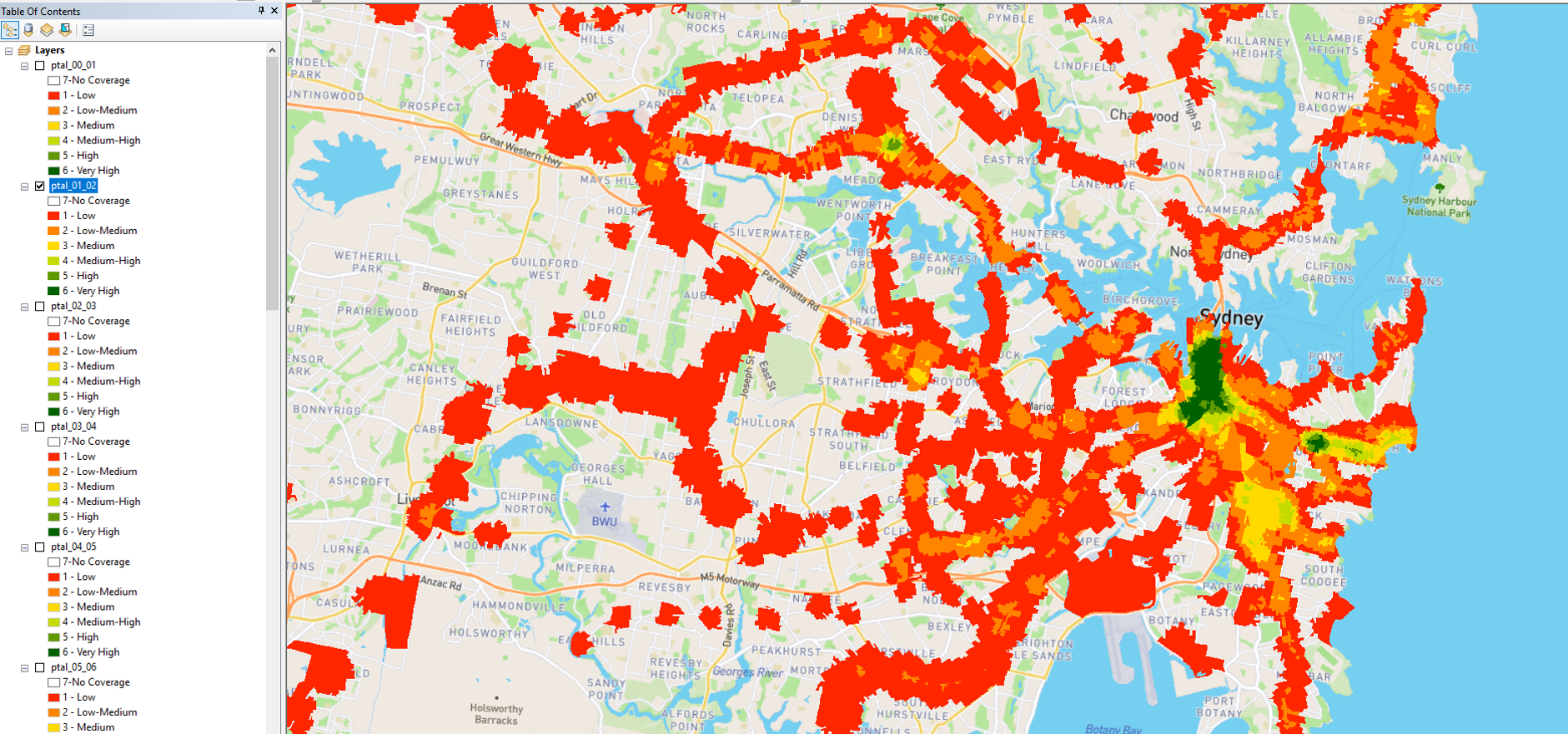
Private mooring licences are only issued to individuals. They’re not issued to a partnership, company, organisation or association. A private mooring licence permits you to moor your vessel on navigable waters. The licence is valid for 12 months. It will be renewed on payment of your annual [private mooring fees](https://www.rms.nsw.gov.au/maritime/moorings/mooring-fees.html#Privatemooringfees). The [RMS Private Moorings](https://www.rms.nsw.gov.au/maritime/moorings/private-moorings/index.html#Findingasuitablemooring) provides additional information regards: \* What is a private mooring licence? \* Finding a suitable mooring \* Applying for a mooring \* Joining a priority wait list Looking for a private mooring in NSW? Use this [map](https://www.rms.nsw.gov.au/maritime/moorings/private-moorings/map/#/cartomap) to find available and priority wait list areas, and to submit your application. 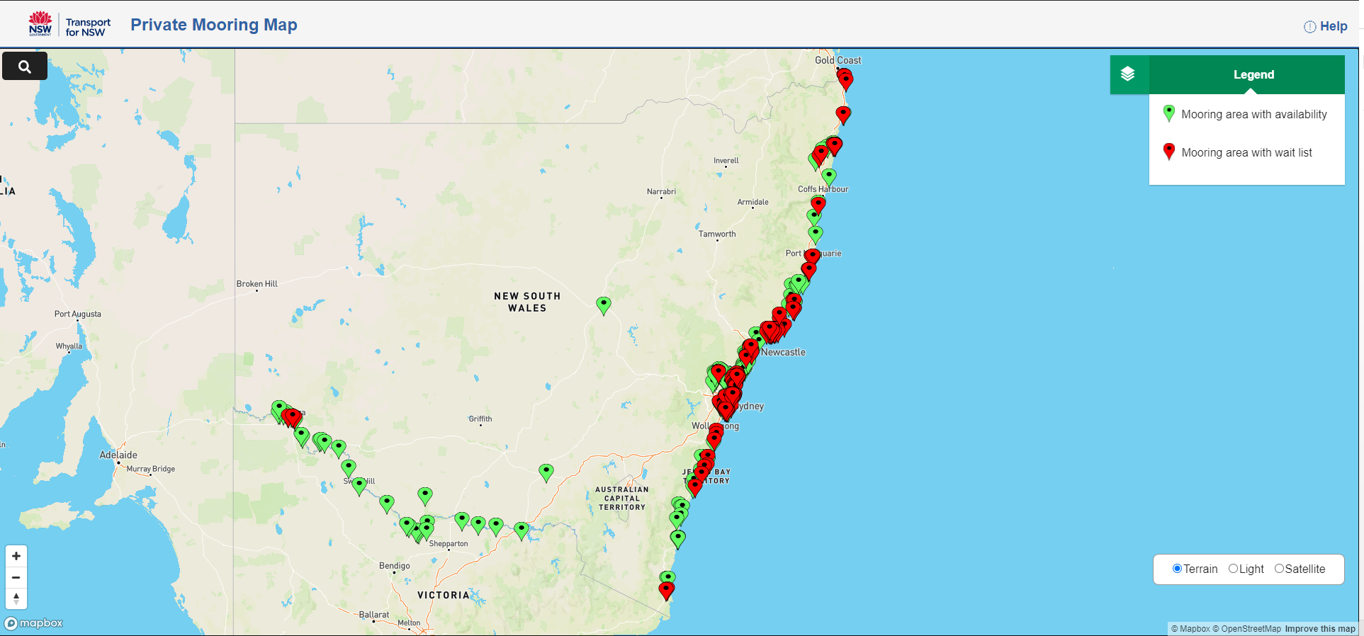
This data is provided by NSW Government Property Acquisitions. The NSW Government is committed to delivering a fair, equitable, and consistent land acquisition process that seeks to acquire properties by mutual agreement. In the interests of transparency and accountability, the Government collects and publishes key property acquisition data from NSW acquiring agencies, as one means of effectively monitoring the performance of the property acquisition framework. The [Property Acquisitions](https://www.propertyacquisition.nsw.gov.au/about-data) website provides you with detailed information about the data available. To view the data for each reporting period, select Go to Resource.
Operator contact details and location facilities for train stations, ferry wharves and bus interchanges. Gateway API is provided for legacy applications, this data is no longer updated and API will be retired in the the near future. To use these resources in your application please follow the CKAN api instructions in the resource description.
Throughout NSW there are buses that run within and between regional centres and towns, the fares for these buses are calculated based on the Fare Band and Number of sections travelled. This dataset provides the regional bus fares for each fare band and section, what the maximum adult single trip fare is and the corresponding adult daily ticket for the fare band and section. Bus operators may choose to set fares below these limits. Eligible concession holders will pay half the adult fare. Eligible concession card holders can access discounted bus fares in regional New South Wales with a [Regional Excursion Daily (RED) ticket](https://transportnsw.info/tickets-opal/regional-tickets-fares/regional-bus-tickets-fares#accordion-regional-excursion-daily-red-tickets-content). The RED ticket provides unlimited local daily bus travel for just $2.50. **The RED ticket is not valid on NSW TrainLink train or coach services.** For Timetables and route maps visit [Transport NSW](https://transportnsw.info/tickets-opal/regional-tickets-fares/regional-bus-tickets-fares).
The Regional Day Return indicator is a measure of regional centre connectivity under the [Future Transport Strategy](https://future.transport.nsw.gov.au/plans/regional-nsw-services-and-infrastructure-plan/customer-outcomes-for-regional-nsw). It aims to provide new connections for regional communities for commuting, attending medical or business appointments, shopping, recreational activities and visiting family and friends. Below is an example of the Regional Day Return indicator catchments 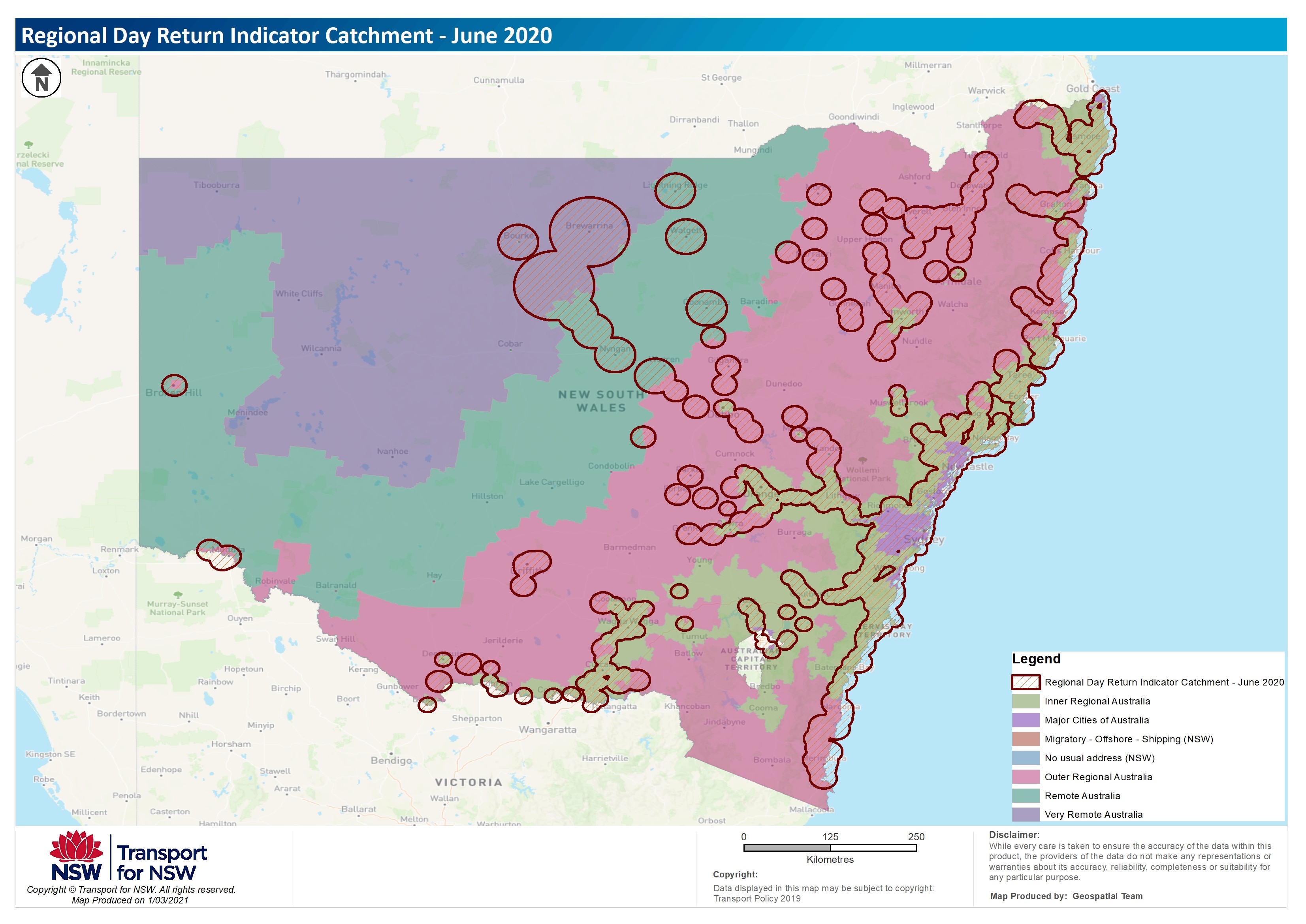 For more information about the trials, the process and datasets used please refer to the Regional Day Return Indicator document.
The Open Data Hub has numerous data relating to roads and speed, whether it be the Sydney Region Carriageway, the Tolls on our NSW roads, or the speed zones and speed camera locations. Below you will find a full list of available data sets; * [NorthConnex](https://opendata.transport.nsw.gov.au/dataset/northconnex) * [Sydney Region Carriageway](https://opendata.transport.nsw.gov.au/dataset/sydney-region-carriageway) * [Road Segment Data from Data.NSW](https://opendata.transport.nsw.gov.au/dataset/road-segment-data-from-datansw) * [NSW Speed Cameras](https://opendata.transport.nsw.gov.au/dataset/nsw-speed-cameras) * [Speed Zones](https://opendata.transport.nsw.gov.au/dataset/speed-zones) * [NSW Toll Road Data](https://opendata.transport.nsw.gov.au/dataset/nsw-toll-road-data) * [NSW Rest Areas](https://opendata.transport.nsw.gov.au/dataset/nsw-rest-areas) * [Toll Calculator API](https://opendata.transport.nsw.gov.au/dataset/toll-calculator-api) * [Toll Calculator](https://opendata.transport.nsw.gov.au/dataset/toll-calculator) * [Historic Roads Travel Time Data (TTDS)](https://opendata.transport.nsw.gov.au/dataset/historic-roads-travel-time-data-ttds) * [NSW Roads Traffic Volume Counts API](https://opendata.transport.nsw.gov.au/dataset/nsw-roads-traffic-volume-counts-api) * [Data on the speeding fines issued by the speeding cameras and NSW Police](https://opendata.transport.nsw.gov.au/dataset/data-on-speeding-fines-issued-speeding-cameras-and-nsw-police) * [Data on the speeding fines by the offender's postcode](https://opendata.transport.nsw.gov.au/dataset/data-on-speeding-fines-offender%E2%80%99s-postcode) * [Traffic Lights Location](https://opendata.transport.nsw.gov.au/dataset/traffic-lights-location) * [Penalty Offences](https://opendata.transport.nsw.gov.au/dataset/penalty-notices) * [NSW Clearways](https://opendata.transport.nsw.gov.au/dataset/nsw-clearways) * [Live Traffic Site Status](https://opendata.transport.nsw.gov.au/dataset/live-traffic-site-status) * [Live Traffic Hazards](https://opendata.transport.nsw.gov.au/dataset/live-traffic-hazards) * [Live Traffic Cameras](https://opendata.transport.nsw.gov.au/dataset/live-traffic-cameras)
School zones help protect children on their way to and from schools at the times and places where they are often in high numbers. The 40km/h school zones are in force on all days which are not a weekend, a public holiday or a publicly notified school holiday for government schools. The lower speed limit reduces the risk and potential severity of a crash. These are school zone timetables, and school zones operate according to the official school terms, even if the associated school does not.
This data set contains station CAD (Computer Aided Design) drawings for the station names **A - C**. The CAD drawings are 2D detailing the layout and platforms of each station. Showing train direction, station entry and exit, facilities and more. The CAD drawings were provided in 2016 so some stations could also be dated/historical in terms of data and details or **unavailable to be published.**
This data set contains station CAD (Computer Aided Design) drawings for the station names **D - G**. The CAD drawings are 2D detailing the layout and platforms of each station. Showing train direction, station entry and exit, facilities and more. The CAD drawings were provided in 2016 so some stations could also be dated/historical in terms of data and details or **unavailable to be published.**
This data set contains station CAD (Computer Aided Design) drawings for the station names **H - L**. The CAD drawings are 2D detailing the layout and platforms of each station. Showing train direction, station entry and exit, facilities and more. The CAD drawings were provided in 2016 so some stations could also be dated/historical in terms of data and details or **unavailable to be published.**
This data set contains station CAD (Computer Aided Design) drawings for the station names **M - O**. The CAD drawings are 2D detailing the layout and platforms of each station. Showing train direction, station entry and exit, facilities and more. The CAD drawings were provided in 2016 so some stations could also be dated/historical in terms of data and details or **unavailable to be published.**
This data set contains station CAD (Computer Aided Design) drawings for the station names **P - R**. The CAD drawings are 2D detailing the layout and platforms of each station. Showing train direction, station entry and exit, facilities and more. The CAD drawings were provided in 2016 so some stations could also be dated/historical in terms of data and details or **unavailable to be published.**
This data set contains station CAD (Computer Aided Design) drawings for the station names **S - V**. The CAD drawings are 2D detailing the layout and platforms of each station. Showing train direction, station entry and exit, facilities and more. The CAD drawings were provided in 2016 so some stations could also be dated/historical in terms of data and details or **unavailable to be published.**
This dataset includes pop-up cycleways in key commuter areas across the city to promote walking and bike riding. The pop-up cycleways is part of a set of initiatives developed across the Sydney region to provide people more options to safely walk, bike ride and commute to work in 2020. The data sets provided are for the pop-up cycleways only. More cycleway (bike paths) data can be referenced from the Cycleway Finder [https://www.rms.nsw.gov.au/maps/cycleway\_finder](https://www.rms.nsw.gov.au/maps/cycleway_finder) and [Open Street Map](https://www.openstreetmap.org).
The NSW Taxi Council is the peak body for the NSW Taxi Industry. It represents taxi networks, owners and operators. This dataset includes location points of the Taxi Ranks in the Sydney Metro area including 15 of the 23 Secure Taxi Ranks. Secure taxi ranks operate late on Friday and Saturday nights in busy locations across NSW. Security guards are on duty to help ensure a safe environment for both customers and drivers. The dataset is as at 31/10/2018, and includes decommissioned Taxi Ranks due to the implementation of the L2 and L3 Light Rail infrastructure and various Pop Up Cycleways, and is missing newly implemented Secure taxi ranks.
This dataset contains the translation (or transliteration) of every station or wharf in the Transport for NSW network in 12 languages: * Arabic * French * German * Greek * Hindi * Italian * Japanese * Korean * Simplified Chinese * Spanish * Traditional Chinese * Vietnamese Each Excel file captures the TSN (Transit Stop Number), Station name in English, Suburb name in English, and the individual language translation. Our preference is for the translated/transliterated version of the station/wharf name to be displayed with the official English station/wharf name for a better customer experience.
Create your own personal public transport trip planner. APIs interact with the transportnsw.info trip planner and provide the ability for NSW public transport trip planning, departure board, travel alerts, real-time transport services and walk and drive legs. Trip Planner API to interact with the Transport for NSW trip planner. This allows users to search for trips, stops, service alerts, places of interest. The Trip Planner API offers five different endpoints: Stop Finder, Trip Planner, Departure, Service Alerts and Coordinate Request APIs. You can find more information about each of these below. Before you start using the API, we encourage you to read all available documentation at [https://opendata.transport.nsw.gov.au/documentation#9](https://opendata.transport.nsw.gov.au/documentation#9) For tips and tricks please visit our Troubleshooting page at [https://opendata.transport.nsw.gov.au/troubleshooting](https://opendata.transport.nsw.gov.au/troubleshooting)