In 2007, Washington State legislators requested a trails database, but funding to complete that statewide project was not made available at the time. In 2009, the Federal Government outlined the need for trails database schema in their Data Standards Review Committee, stressing the efficiency in management decisions that a streamlined database can provide. “The collection, storage and management of trail related data are important components of everyday business activities in many federal and state land-managing agencies, trail organizations and businesses. From a management perspective, trails data must often mesh closely with other types of infrastructure, resource and facility enterprise data.” In 2014, the Washington State Office of the Chief Information Officer's (OCIO) Geospatial Program Office acquired a Nonhighway and Off-Road Vehicle Activities (NOVA) Program grant through the Washington State Recreation and Conservation Office (RCO) giving the OCIO initial funding to develop a statewide trails database based on Federal Geographic Data Committee standards. Using the same standard for all trails data will allow land managers and recreational users throughout the state to access and use the data regardless of administrative boundary. "Data standards will make it easier for trail information to be accessed and exchanged and used by more than one individual agency or group…Ease in sharing data increases the capability for enhanced and consistent mapping, inventory, monitoring, conditions assessment, maintenance, costing, budgeting, information retrieval, and summary reporting for internal and external needs.” Along with streamlining data and facilitating efficiency in management practices across agencies, the database will provide a source of trails information that is open and free to the public. The 2016 State Legislature provided additional funding from the Nonhighway and Off-road Vehicle Activities Account to the Office of the Chief Information Officer to continue work on the database. Additional details about the project can be found here: http://rco.wa.gov/recreation/WashingtonStateTrailsMap.shtml Please note that this map and its component services have been designed to work together as part of the web application.
This data is provided by the City of Sydney and provides bicycle parking locations. There are more than 3000 public bike parking spaces in the City of Sydney's area. There are 32 free bicycle parking spaces at Kings Cross car park level 5. Goulburn Street car park has 9 individual bike cages for casual use, as well as a free secure cage with 24 spaces that can be accessed with a pass. The API provides data in GeoJSON format, for more information visit [City of Sydney](https://data.cityofsydney.nsw.gov.au/datasets/bicycle-parking-1?geometry=150.877%2C-33.938%2C151.531%2C-33.838).
This data is provided by the City of Sydney and provides bus shelter locations. There are 40 public bus shelters controlled by the City of Sydney. The API provides data in GeoJSON format, for more information visit [City of Sydney](https://data.cityofsydney.nsw.gov.au/datasets/bus-shelters).
Some Intercity trains may be longer than the platform at their destination. This dataset has detailed information on the Cars (carriages) that customers can alight from at stations on the following Intercity lines: \* Blue Mountains \* Central Coast & Newcastle \* Hunter \* South Coast \* Southern Highlands To safely exit the train you must travel in the correct car when travelling. It’s important that you check and travel in the correct car so you can exit the train at your destination. Keep in mind, Car One is always at the front of the train. This dataset captures all the Intercity Train Platforms, the maximum Cars per train, if the train aligns with the front or rear of the platform, and how many cars are off the platform for that respective station. This data is also available in GTFS-Vehicles format in the [Sydney Trains GTFS bundle](https://opendata.transport.nsw.gov.au/node/332/exploreapi#!/sydneytrains/GetSydneyTrains) Please refer to the [Sydney Trains Realtime GTFS & GTFS- R Technical Document](https://opendata.transport.nsw.gov.au/sites/default/files/Real%20Time%20Train%20Technical%20Document%20v3_2_open%20data.pdf) in order to determine the set type and number of cars for each timetabled trip.
Application allowing the search of public water systems for water supply in NM.
PTAL is a measure of connectivity by public transport, which has been used in various planning processes for many years. For any selected place, PTAL suggests how well the place is connected to public transport services. It does not cover trips by car. The PTAL model calculates December 2019 public transport accessibility for every 2016 ABS Mesh Block in New South Wales. The TfNSW PTAL model is based on the Transport for London (TfL) PTAL and was adapted for TfNSW in collaboration with the Spatial Information Science team at the Department of Earth and Environmental Sciences, Macquarie University. The [Assessing transport connectivity in London](http://content.tfl.gov.uk/connectivity-assessment-guide.pdf) explains what PTAL is, how to understand the data and more. PTAL values are simple. They range from zero to six, where the highest value represents the best connectivity. A location will have a higher PTAL if: \* It is at a short walking distance to the nearest stations or stops \* Waiting times at the nearest stations or stops are short \* More services pass at the nearest stations or stops \* There are major rail stations nearby \* Any combination of all the above. Please read the PTAL documentation for more information. The format of the data is Arcgis geodatabase. **Images below show an example of what the data looks like at 8:00am (first image) and 1:00am (second image)**. 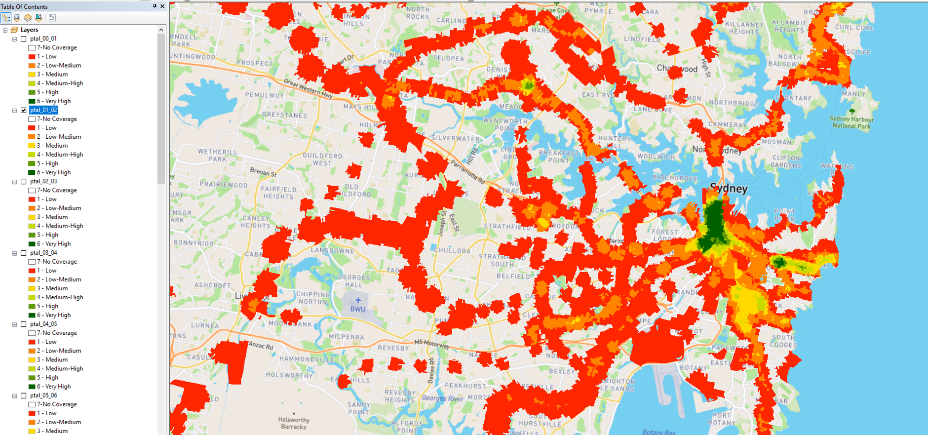
This data is provided by NSW Government Property Acquisitions. The NSW Government is committed to delivering a fair, equitable, and consistent land acquisition process that seeks to acquire properties by mutual agreement. In the interests of transparency and accountability, the Government collects and publishes key property acquisition data from NSW acquiring agencies, as one means of effectively monitoring the performance of the property acquisition framework. The [Property Acquisitions](https://www.propertyacquisition.nsw.gov.au/about-data) website provides you with detailed information about the data available. To view the data for each reporting period, select Go to Resource.
Operator contact details and location facilities for train stations, ferry wharves and bus interchanges. Gateway API is provided for legacy applications, this data is no longer updated and API will be retired in the the near future. To use these resources in your application please follow the CKAN api instructions in the resource description.
Realtime alerts at either the stop, trip, or service line level in GTFS-realtime format for Bus, Train, Ferry, Light Rail, Metro and Coaches.
Current vehicle positions in GTFS-realtime format for Buses, Ferries, Light Rail, Trains, Metro and Regional Bus Services (our regional services are at times referenced as "TCB" - Transport Connected Bus). An up to date list of all TCB services can be found [on the forum](https://opendataforum.transport.nsw.gov.au/t/new-real-time-regional-bus-data-is-now-available/2060).
Current vehicle positions in GTFS-realtime format for Metro and Sydney Trains.
Static timetables, stop locations, pathways for trains, and route shape information in GTFS format for operators that support realtime. Covers Buses, Ferries, Light Rail, Trains, Metro and Regional Bus Services (our regional services are at times referenced as "TCB" - Transport Connected Bus). An up to date list of all TCB services can be found [on the forum](https://opendataforum.transport.nsw.gov.au/t/new-real-time-regional-bus-data-is-now-available/2060).
Static timetables, stop locations, pathways for trains, and route shape information in GTFS format for operators that support realtime.
The Regional Day Return indicator is a measure of regional centre connectivity under the [Future Transport Strategy](https://future.transport.nsw.gov.au/plans/regional-nsw-services-and-infrastructure-plan/customer-outcomes-for-regional-nsw). It aims to provide new connections for regional communities for commuting, attending medical or business appointments, shopping, recreational activities and visiting family and friends. Below is an example of the Regional Day Return indicator catchments 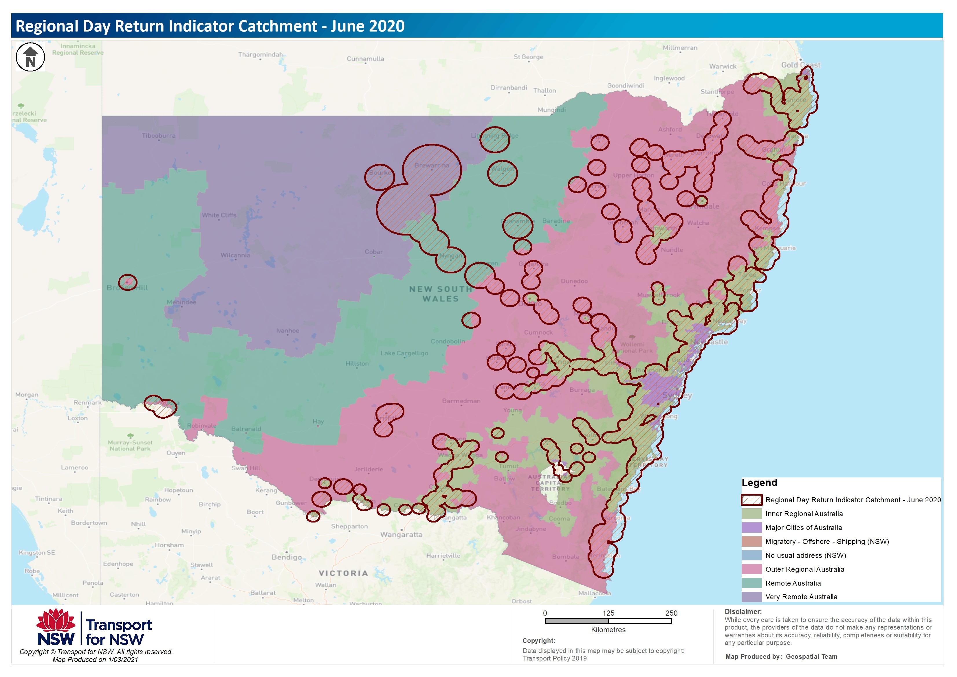 For more information about the trials, the process and datasets used please refer to the Regional Day Return Indicator document.
This dataset includes NSW public school term dates and public holidays. The Department of Education sets the term and school holiday dates for all NSW public schools: [https://education.nsw.gov.au/public-schools/going-to-a-public-school/cal...](https://education.nsw.gov.au/public-schools/going-to-a-public-school/calendars/future-and-past-nsw-term-and-vacation-dates) School development days occur at the beginning of Terms 1, 2 and 3 and the last two days of the school year. Check with your school, as schools may vary some of these dates. NSW public holidays are available here: [https://www.industrialrelations.nsw.gov.au/public-holidays/public-holida...](https://www.industrialrelations.nsw.gov.au/public-holidays/public-holidays-in-nsw/) The data resources contain historic, current and future dates. [Local Public Holidays in NSW](https://www.industrialrelations.nsw.gov.au/public-holidays/local-public-holidays-in-nsw/) captures additional holiday dates for specific localities.
The Shoreline Public Access Project is a geographic information systems (GIS) project to identify the location, length, and degree of public access to Washington State's marine shoreline. Before the project, it was unknown how much of Washington's 3066 miles of shoreline was public. The information was scattered throughout various government agencies and the data quality was variable. Through the Shoreline Public Access Project, the best available information has been summarized into a single data set, used to answer questions about our shoreline's ownership and public accessibility.For more information, contact Christina Kellum, Washington State Department of Ecology GIS Manager, gis@ecy.wa.gov.
This dataset captures the following public transport performance reports. Each resource is displayed as an interactive chart with filter options. The [TfNSW passenger travel](https://www.transport.nsw.gov.au/data-and-research/passenger-travel#Performance_reports) provides more information. * Sydney Metropolitan and Outer Metropolitan Bus Service Contract on time running results * Ferries service Reliability and On-Time Running Results * NSW Trains service reliability and punctuality results on all regional lines in New South Wales. * Sydney Trains and NSW TrainLink (Intercity) performance reports * New Customer On-Time measure – measuring our customer’s experience * Sydney Network - Historical Trains Punctuality Performance report * Performance Reporting for the Sydney Light Rail network Use the **GO TO RESOURCE** Option to view the individual reports.
Thirty Minute City and Metro Strategic Centre Catchments is a foundation of the [Future Transport Strategy](https://future.transport.nsw.gov.au/future-transport-strategy/greater-sydney-network). Thirty Minute City establishes a metropolitan transport network which reinforces the metropolis of three cities, particularly the delivery of a 30-minute city where most residents in each city can access their metropolitan centre or cluster within 30 minutes by public transport. Metro Strategic Centre Catchments develops a network of 34 strategic centres with jobs, goods and services supported by a public transport, walking and cycling network. This would provide residents with a 30-minute public transport service to their nearest strategic centre seven days a week. The image below shows the thirty minute city catchments to the different strategic centre catchments. 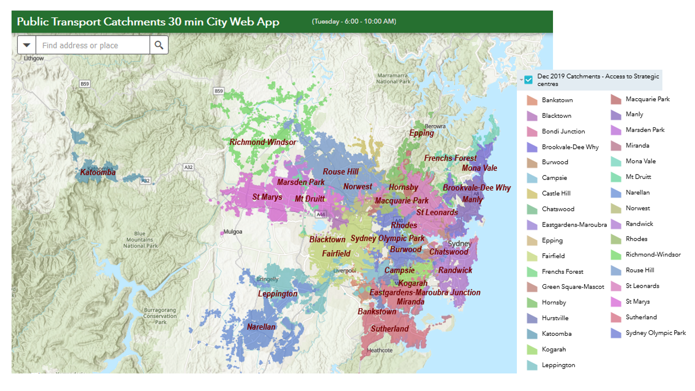 The Thirty Minute City and Metro Strategic Centre Catchments Document provides you with detailed information regards the background of this initiative and the datasets used.
The NDMPL (Washington State Non-Department of Natural Resources Major Public Lands) data contains ownership parcels for Federal, State (excluding WA DNR), County and City lands within the State of Washington. It also includes Tribal administrative boundaries. The NDMPL data layer is a polygon dataset and does not contain arc attribute information for ownership boundaries. This data is not connected to WA DNR's Cadastre layers (these data include WADNR ownership, Public Land Survey System and other cadastral data). As updates are made to Cadastre layers, they may not be reflected in NDMPL.WA Major Public Lands MetadataClick to downloadThis layer has updated October 2021.
The trailhead database was created in conjunction with the Washington State Trails Database project. The attributes included in this database were chosen to supplement information found in the trails database, so using the two together is recommended. This project did not create new georeferenced locations; the aim was to design a geodatabase, include as many existing trailheads as possible, and answer common questions regarding use and availability. It is not comprehensive. Additional details about the project can be found here: http://www.rco.wa.gov/recreation/WashingtonStateTrailsMap.shtml Please note that this service has been designed to supplement other services in the map and web application.
In 2007, Washington State legislators requested a trails database, but funding to complete that statewide project was not made available at the time.In 2009, the Federal Government outlined the need for trails database schema in their Data Standards Review Committee, stressing the efficiency in management decisions that a streamlined database can provide.“The collection, storage and management of trail related data are important components of everyday business activities in many federal and state land-managing agencies, trail organizations and businesses. From a management perspective, trails data must often mesh closely with other types of infrastructure, resource and facility enterprise data.”In 2014, the Washington State Office of the Chief Information Officer's (OCIO) Geospatial Program Office acquired a Nonhighway and Off-Road Vehicle Activities (NOVA) Program grant through the Washington State Recreation and Conservation Office (RCO) giving the OCIO initial funding to develop a statewide trails database based on Federal Geographic Data Committee standards. Using the same standard for all trails data will allow land managers and recreational users throughout the state to access and use the data regardless of administrative boundary."Data standards will make it easier for trail information to be accessed and exchanged and used by more than one individual agency or group…Ease in sharing data increases the capability for enhanced and consistent mapping, inventory, monitoring, conditions assessment, maintenance, costing, budgeting, information retrieval, and summary reporting for internal and external needs.”Along with streamlining data and facilitating efficiency in management practices across agencies, the database will provide a source of trails information that is open and free to the public.The 2016 State Legislature provided additional funding from the Nonhighway and Off-road Vehicle Activities Account to the Office of the Chief Information Officer to continue work on the database.Additional details about the project can be found here:http://rco.wa.gov/recreation/WashingtonStateTrailsMap.shtml Please note that this map and its component services have been designed to work together as part of the web application.
In 2007, Washington State legislators requested a trails database, but funding to complete that statewide project was not made available at the time.In 2009, the Federal Government outlined the need for trails database schema in their Data Standards Review Committee, stressing the efficiency in management decisions that a streamlined database can provide.“The collection, storage and management of trail related data are important components of everyday business activities in many federal and state land-managing agencies, trail organizations and businesses. From a management perspective, trails data must often mesh closely with other types of infrastructure, resource and facility enterprise data.”In 2014, the Washington State Office of the Chief Information Officer's (OCIO) Geospatial Program Office acquired a Nonhighway and Off-Road Vehicle Activities (NOVA) Program grant through the Washington State Recreation and Conservation Office (RCO) giving the OCIO initial funding to develop a statewide trails database based on Federal Geographic Data Committee standards. Using the same standard for all trails data will allow land managers and recreational users throughout the state to access and use the data regardless of administrative boundary."Data standards will make it easier for trail information to be accessed and exchanged and used by more than one individual agency or group…Ease in sharing data increases the capability for enhanced and consistent mapping, inventory, monitoring, conditions assessment, maintenance, costing, budgeting, information retrieval, and summary reporting for internal and external needs.”Along with streamlining data and facilitating efficiency in management practices across agencies, the database will provide a source of trails information that is open and free to the public.The 2016 State Legislature provided additional funding from the Nonhighway and Off-road Vehicle Activities Account to the Office of the Chief Information Officer to continue work on the database.Additional details about the project can be found here:http://rco.wa.gov/recreation/WashingtonStateTrailsMap.shtml Please note that this map and its component services have been designed to work together as part of the web application.
In 2007, Washington State legislators requested a trails database, but funding to complete that statewide project was not made available at the time.In 2009, the Federal Government outlined the need for trails database schema in their Data Standards Review Committee, stressing the efficiency in management decisions that a streamlined database can provide.“The collection, storage and management of trail related data are important components of everyday business activities in many federal and state land-managing agencies, trail organizations and businesses. From a management perspective, trails data must often mesh closely with other types of infrastructure, resource and facility enterprise data.”In 2014, the Washington State Office of the Chief Information Officer's (OCIO) Geospatial Program Office acquired a Nonhighway and Off-Road Vehicle Activities (NOVA) Program grant through the Washington State Recreation and Conservation Office (RCO) giving the OCIO initial funding to develop a statewide trails database based on Federal Geographic Data Committee standards. Using the same standard for all trails data will allow land managers and recreational users throughout the state to access and use the data regardless of administrative boundary."Data standards will make it easier for trail information to be accessed and exchanged and used by more than one individual agency or group…Ease in sharing data increases the capability for enhanced and consistent mapping, inventory, monitoring, conditions assessment, maintenance, costing, budgeting, information retrieval, and summary reporting for internal and external needs.”Along with streamlining data and facilitating efficiency in management practices across agencies, the database will provide a source of trails information that is open and free to the public.The 2016 State Legislature provided additional funding from the Nonhighway and Off-road Vehicle Activities Account to the Office of the Chief Information Officer to continue work on the database.Additional details about the project can be found here:http://rco.wa.gov/recreation/WashingtonStateTrailsMap.shtml Please note that this map and its component services have been designed to work together as part of the web application.
In 2007, Washington State legislators requested a trails database, but funding to complete that statewide project was not made available at the time.In 2009, the Federal Government outlined the need for trails database schema in their Data Standards Review Committee, stressing the efficiency in management decisions that a streamlined database can provide.“The collection, storage and management of trail related data are important components of everyday business activities in many federal and state land-managing agencies, trail organizations and businesses. From a management perspective, trails data must often mesh closely with other types of infrastructure, resource and facility enterprise data.”In 2014, the Washington State Office of the Chief Information Officer's (OCIO) Geospatial Program Office acquired a Nonhighway and Off-Road Vehicle Activities (NOVA) Program grant through the Washington State Recreation and Conservation Office (RCO) giving the OCIO initial funding to develop a statewide trails database based on Federal Geographic Data Committee standards. Using the same standard for all trails data will allow land managers and recreational users throughout the state to access and use the data regardless of administrative boundary."Data standards will make it easier for trail information to be accessed and exchanged and used by more than one individual agency or group…Ease in sharing data increases the capability for enhanced and consistent mapping, inventory, monitoring, conditions assessment, maintenance, costing, budgeting, information retrieval, and summary reporting for internal and external needs.”Along with streamlining data and facilitating efficiency in management practices across agencies, the database will provide a source of trails information that is open and free to the public.The 2016 State Legislature provided additional funding from the Nonhighway and Off-road Vehicle Activities Account to the Office of the Chief Information Officer to continue work on the database.Additional details about the project can be found here: http://rco.wa.gov/recreation/WashingtonStateTrailsMap.shtmlPlease note that this map and its component services have been designed to work together as part of the web application.
In 2007, Washington State legislators requested a trails database, but funding to complete that statewide project was not made available at the time. In 2009, the Federal Government outlined the need for trails database schema in their Data Standards Review Committee, stressing the efficiency in management decisions that a streamlined database can provide. “The collection, storage and management of trail related data are important components of everyday business activities in many federal and state land-managing agencies, trail organizations and businesses. From a management perspective, trails data must often mesh closely with other types of infrastructure, resource and facility enterprise data.” In 2014, the Washington State Office of the Chief Information Officer's (OCIO) Geospatial Program Office acquired a Nonhighway and Off-Road Vehicle Activities (NOVA) Program grant through the Washington State Recreation and Conservation Office (RCO) giving the OCIO initial funding to develop a statewide trails database based on Federal Geographic Data Committee standards. Using the same standard for all trails data will allow land managers and recreational users throughout the state to access and use the data regardless of administrative boundary. "Data standards will make it easier for trail information to be accessed and exchanged and used by more than one individual agency or group…Ease in sharing data increases the capability for enhanced and consistent mapping, inventory, monitoring, conditions assessment, maintenance, costing, budgeting, information retrieval, and summary reporting for internal and external needs.” Along with streamlining data and facilitating efficiency in management practices across agencies, the database will provide a source of trails information that is open and free to the public.The 2016 State Legislature provided additional funding from the Nonhighway and Off-road Vehicle Activities Account to the Office of the Chief Information Officer to continue work on the database. Additional details about the project can be found here: http://rco.wa.gov/recreation/WashingtonStateTrailsMap.shtml Please note that this map and its component services have been designed to work together as part of the web application.