Data contains sampling station locations with physical and chemical data. Data: stations 508.xlsx (Ohio dataset), env.bio70 508.xlsx (WV biological station dataset). This dataset is associated with the following publication: Cormier, S., L. Zheng, G. Suter, and C. Flaherty. Assessing background levels of specific conductivity using weight of evidence. SCIENCE OF THE TOTAL ENVIRONMENT. Elsevier BV, AMSTERDAM, NETHERLANDS, 628-629: 1637-1649, (2018).
The submission includes wave resource classification reports, summary of classification statistics and regional trends, and data files with classification statistics for selected sites for extreme significant wave height. Two conference papers were uploaded that include classification metrics and geographic distributions for US coastal waters. These conference papers are: Neary, V.S., Coe, R.G., Cruz, J., Haas, K., Bacelli, G., Debruyne, Y., Ahn, S., Nevarez, V. (2017) Classification systems for wave energy resources and WEC technologies. Proceedings of 12th European Wave and Tidal Energy Conference Series (EWTEC 2017), Cork, Ireland, August 27-September 1, 2017 Haas, K., Ahn, S., Neary, V.S., and S. Bredin (2017) Development of a wave energy classification system. Proceedings of the 5th Marine Energy Technology Symposium (METS2017), Washington, D.C., May 1-3, 2017
This dataset contains approximate GIS (geographic information system) geospatial boundaries for each of the DNO License Areas in Great Britain. There are 14 licensed Distribution Network Operators (DNOs) in Britain and each is responsible for a regional distribution services area. DNO License Areas are sometimes referred to as GSP Groups and historically have also been known as Public Electricity Supplier (PES) regions, though the latter name is no longer widely used. The DNO License Area boundaries are unusual because they are only well defined when tested. The boundaries tend to run through rural areas and change over time whenever a new connection is added close to a boundary. For example, a new connection close to an existing boundary can approach the DNO responsible for both neighbouring License Areas to ask for a connection, and is free to choose either depending on how much they will charge - once the new connection is made the boundary is, theoretically, re-drawn to ensure that the new connection falls into the correct License Area. The boundaries in this dataset were shared by Western Power Distribution (the DNO responsible for 4 of the 14 License Areas) and come with the disclaimer that they are probably a little outdated and not 100% accurate. That said, they are a good indication of the geography of DNO License Areas. DNO License Areas are widely used as an aggregation entity when reporting electricity network data, for example, in Elexon's publication of electricity settlement data. As such, they are also useful for regional modelling of the GB electricity transmission network, for example to aggregate distributed embedded generator energy flows onto the transmission network. A good example of this is the Regional PV_Live outturn estimates published by The University of Sheffield (https://www.solar.sheffield.ac.uk/pvlive/regional/).
This is the regional dataset compilation for the INnovative Geothermal Exploration through Novel Investigations Of Undiscovered Systems (INGENIOUS) project. The primary goal of this project is to accelerate discoveries of new, commercially viable hidden geothermal systems while reducing the exploration and development risks for all geothermal resources. These datasets will be used in INGENIOUS as input features for predicting geothermal favorability throughout the Great Basin study area. Datasets consist of shapefiles, geotiffs, tabular spreadsheets, and metadata that describe: 2-meter temperature probe surveys, quaternary faults and volcanic features, geodetic shear and dilation models, heat flow, magnetotellurics (conductance), magnetics, gravity, paleogeothermal features (such as sinter and tufa deposits), seismicity, spring and well temperatures, spring and well aqueous geochemistry analyses, thermal conductivity, and fault slip and dilation tendency. For additional project information, see the INGENIOUS project site linked in the submission. Terms of use: These datasets are provided "as is", and the contributors assume no responsibility for any errors or omissions. The user assumes the entire risk associated with their use of these data and bears all responsibility in determining whether these data are fit for their intended use. These datasets may be redistributed with attribution (see citation information below). Please refer to the license information on this page for full licensing terms and conditions.
This dataset contains patronage statistics for all intrastate air services to and from Sydney airport. This data is collected quarterly under the Air Transport Regulation 2016. The patronage data dates back to 1996/97.
This dataset contains NSW Trainlink train and coach (bus) utilisation figures. The data is aggregated to a total monthly figure representing the estimated number of trips. The resource captures the service number, service name and the monthly figures for each service.
The National Water Census is a USGS research program on national water availability and use that develops new water accounting tools and assesses water availability at the regional and national scales. Through the Water Census, USGS is integrating diverse research on water availability and use and enhancing the understanding of connection between water quality and water availability. Research is designed to build decision support capacity for water management agencies and other natural resource managers.
Prompt Payments by Public Sector Bodies Reporting Template pursuant to Government Decision S29296
Prompt Payments by Public Sector Bodies Reporting Template pursuant to Government Decision S29296
Prompt Payments by Public Sector Bodies Reporting Template pursuant to Government Decision S29296
Prompt Payments by Public Sector Bodies Reporting Template pursuant to Government Decision S29296
Current vehicle positions in GTFS-realtime format for Buses, Ferries, Light Rail, Trains, Metro and Regional Bus Services (our regional services are at times referenced as "TCB" - Transport Connected Bus). An up to date list of all TCB services can be found [on the forum](https://opendataforum.transport.nsw.gov.au/t/new-real-time-regional-bus-data-is-now-available/2060).
Throughout NSW there are buses that run within and between regional centres and towns, the fares for these buses are calculated based on the Fare Band and Number of sections travelled. This dataset provides the regional bus fares for each fare band and section, what the maximum adult single trip fare is and the corresponding adult daily ticket for the fare band and section. Bus operators may choose to set fares below these limits. Eligible concession holders will pay half the adult fare. Eligible concession card holders can access discounted bus fares in regional New South Wales with a [Regional Excursion Daily (RED) ticket](https://transportnsw.info/tickets-opal/regional-tickets-fares/regional-bus-tickets-fares#accordion-regional-excursion-daily-red-tickets-content). The RED ticket provides unlimited local daily bus travel for just $2.50. **The RED ticket is not valid on NSW TrainLink train or coach services.** For Timetables and route maps visit [Transport NSW](https://transportnsw.info/tickets-opal/regional-tickets-fares/regional-bus-tickets-fares).
The Regional Day Return indicator is a measure of regional centre connectivity under the [Future Transport Strategy](https://future.transport.nsw.gov.au/plans/regional-nsw-services-and-infrastructure-plan/customer-outcomes-for-regional-nsw). It aims to provide new connections for regional communities for commuting, attending medical or business appointments, shopping, recreational activities and visiting family and friends. Below is an example of the Regional Day Return indicator catchments 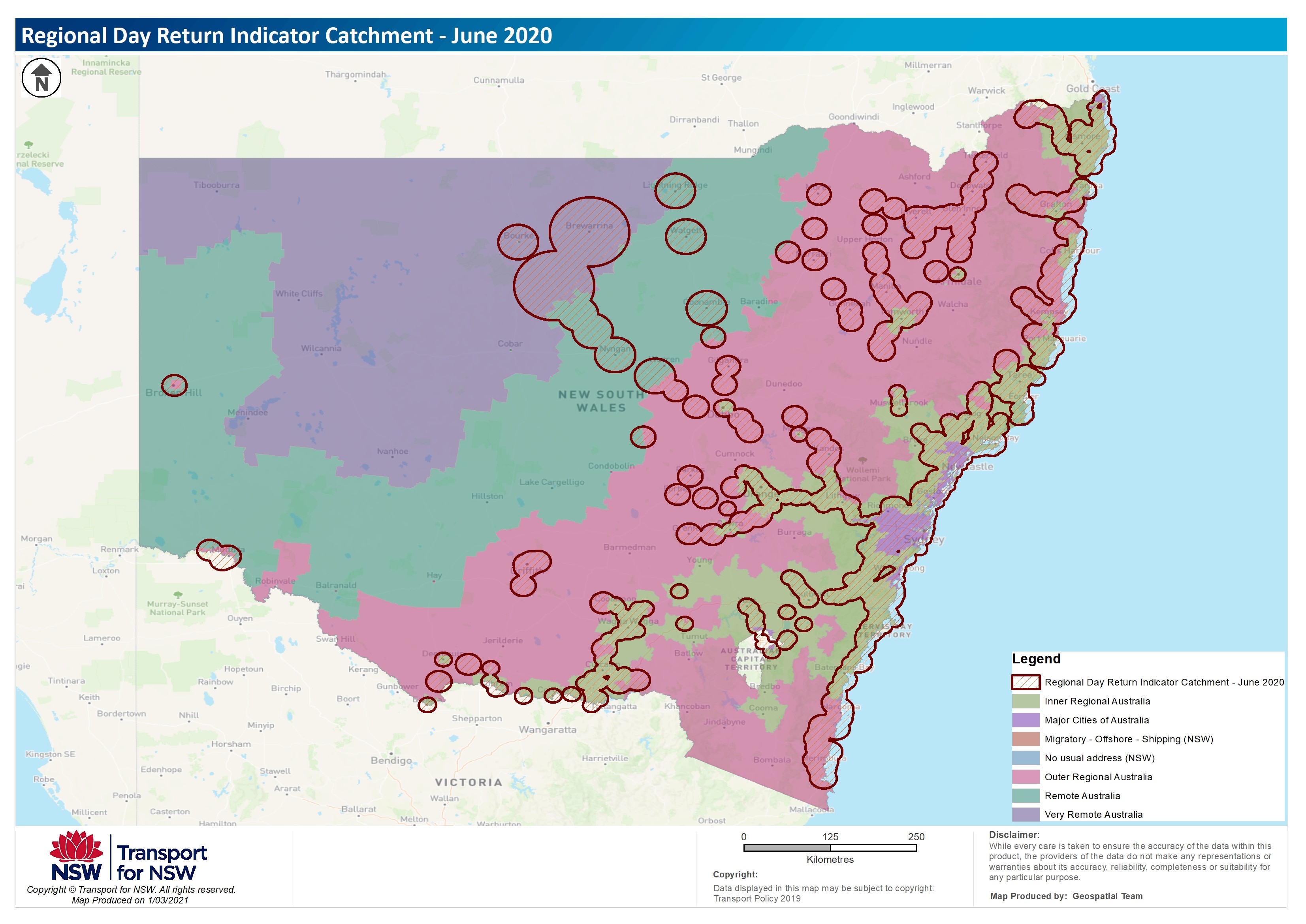 For more information about the trials, the process and datasets used please refer to the Regional Day Return Indicator document.
Prompt Payments by Public Sector Bodies Reporting Template pursuant to Government Decision S29296