Open Net Zero logo

Filters

Formats:
Select...
Licenses:
Select...
Organizations:
Select...
Tags:
Select...
Shared:
Sensitivities:
Datasets
L o a d i n g
Implementation Guide for Quality Assurance Programs for Basic and Applied Research

Implementation Guide for Quality Assurance Programs for Basic and Applied Research

0
No licence known
Tags:
Geologyassurancebasicguideimplementationprogramqualityresearch
Formats:
PDF
National Energy Technology Laboratory (NETL)about 1 year ago
MHKDR Data Management and Best Practices for Submitters and CuratorsSource

Resources for MHKDR data submitters and curators, including training videos, step-by-step guides on data submission, and detailed documentation of the MHKDR. The Data Management and Submission Best Practices document also contains API access and metadata schema information for developers interested in harvesting MHKDR metadata for federation or inclusion in their local catalogs.

0
No licence known
Tags:
APIHydrokineticMHKMHKDRMarinebest practicesdataenergyfederationguidemanagementmetadatapowerstandardsstoragesubmissiontraining
Formats:
HTMLPDF
National Renewable Energy Laboratory (NREL)about 1 year ago
OEDI Data Management and Best Practices for Submitters and CuratorsSource

Resources for OEDI data submitters and curators, including training videos, step-by-step guides on data submission, and detailed documentation of OEDI. The Data Management and Submission Best Practices document also contains API access and metadata schema information for developers interested in harvesting OEDI metadata for federation or inclusion in their local catalogs.

0
No licence known
Tags:
APIOEDIbest practicesdataenergyfederationguidemanagementmetadatapowerstandardsstoragesubmissiontraining
Formats:
PDFHTML
National Renewable Energy Laboratory (NREL)about 1 year ago
Sydney Light Rail Stop GuidesSource

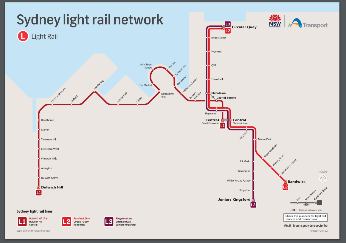
The Sydney light rail network is a light rail system serving the Australian city of Sydney. The network currently consists of three passenger routes, the L1 Dulwich Hill, L2 Randwick and L3 Kingsford lines. This dataset provides WCAG 2.0 compliant wayfinding maps for 42 Sydney light rail stops. Each map displays the local area map and the stop map providing information such as transport connections, customer assistance and tickets. **Current Sydney light rail network** ![sydney light rail network map](https://opendata.transport.nsw.gov.au/sites/default/files/styles/panopoly_image_original/public/Sydney%20light%20rail%20network.PNG?itok=tILH7JlX)

0
Creative Commons Attribution
Tags:
L1L2L3SydneyTransportationguideguideslight raillightrailnetworkstopsystemtransport
Formats:
ZIPPDF
Transport for NSWabout 1 month ago