OverviewL1L2L3SydneyTransportationguideguideslight raillightrailnetworkstopsystemtransport
The Sydney light rail network is a light rail system serving the Australian city of Sydney. The network currently consists of three passenger routes, the L1 Dulwich Hill, L2 Randwick and L3 Kingsford lines. This dataset provides WCAG 2.0 compliant wayfinding maps for 42 Sydney light rail stops. Each map displays the local area map and the stop map providing information such as transport connections, customer assistance and tickets. **Current Sydney light rail network** 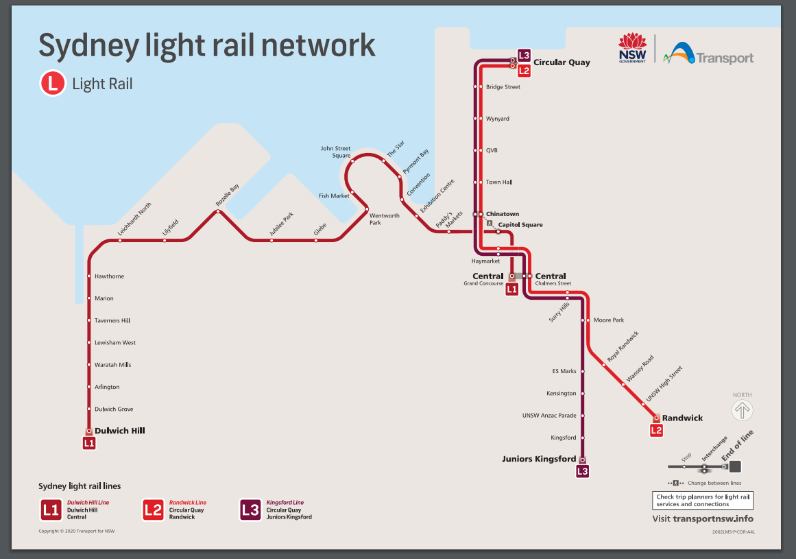
Additional Information
KeyValue
harvest_object_idb426680b-52f6-4e17-9080-aade00911a1e
harvest_source_iddf858780-376c-4c35-8914-1e33d0336116
harvest_source_titleTransport for NSW Open Data Hub
Files
- ZIPL1 Stop Guides
- PDFArlington stop guide
- PDFBridge Street stop guide
- PDFCapitol Square stop guide
- PDFCentral Chalmers Street stop guide
- PDFCentral Grand Concourse stop guide
- PDFChinatown Stop guide
- PDFCircular Quay stop guide
- PDFConvention Stop Guide
- PDFDulwich Hill Stop Guide
- PDFDulwich Grove Stop Guide
- PDFES Marks Stop guide
- PDFExhibition Centre Stop Guide
- PDFFish Market Stop Guide
- PDFGlebe Stop Guide
- PDFHawthorne Stop Guide
- PDFHaymarket Stop guide
- PDFJohn Street Square Stop Guide
- PDFJubilee Park Stop Guide
- PDFJuniors Kingsford Stop guide
- PDFKensington Stop guide
- PDFKingsford Stop guide
- PDFLeichhardt North Stop Guide
- PDFLilyfield Stop Guide
- PDFLewisham Stop Guide
- PDFMarion Stop Guide
- PDFMoore Park Stop guide
- PDFPaddy's Markets Stop Guide
- PDFPyrmont Bay Stop Guide
- PDFQVB stop guide
- PDFRandwick Stop guide
- PDFRoyal Randwick Stop guide
- PDFRozelle Bay Stop Guide
- PDFSurry Hills Stop guide
- PDFTaverners Hill Stop Guide
- PDFThe Star Stop Guide
- PDFTown Hall stop guide
- PDFUNSW Anzac Pde Stop guide
- PDFUNSW High St Stop guide
- PDFWaratah Mills Stop Guide
- PDFWentworth Park Stop Guide
- PDFWansey Rd Stop guide
- PDFWynyard stop guide
- PDFRoyal Randwick stop guide (Effective to 4 Dec 2021)
- PDFES Marks stop guide (Effective to 4 Dec 2021)
- PDFChinatown stop guide (Effective to 4 Dec 2021)
- PDFJuniors Kingsford stop guide (Effective to 4 Dec 2021)
- PDFMoore Park stop guide (Effective to 4 Dec 2021)
- PDFRandwick stop guide (Effective to 4 Dec 2021)
- PDFHaymarket stop guide
- PDFKingsford stop guide (Effective to 4 Dec 2021)
- PDFSurry Hills stop guide (Effective to 4 Dec 2021)
- PDFKensington stop guide (Effective to 4 December 2021)
- PDFUNSW Anzac Parade stop guide (Effective to 4 Dec 2021)
- PDFUNSW High Street stop guide (Effective to 4 Dec 2021)
- PDFWansey Road stop guide (Effective to 4 December 2021)
- PDFArlington stop guide (effective to Nov 2021)
- PDFCapitol Square stop guide (effective to Nov 2021)
- PDFCentral Grand Concourse stop guide (effective to Nov 2021)
- PDFConvention stop guide (effective to Nov 2021)
- PDFDulwich Grove stop guide (effective to Nov 2021)
- PDFDulwich Hill stop guide (effective to Nov 2021)
- PDFExhibition Centre stop guide (effective to Nov 2021)
- PDFFish Market stop guide (effective to 2021)
- PDFGlebe stop guide (effective to Nov 2021)
- PDFHawthorne stop guide (effective to Nov 2021)
- PDFJohn Street Square stop guide (effective to Nov 2021)
- PDFJubilee Park stop guide (effective to Nov 2021)
- PDFLeichhardt North stop guide (effective to Nov 2021)
- PDFLilyfield stop guide (effective to Nov 2021)
- PDFLewisham West stop guide (effective to Nov 2021)
- PDFMarion stop guide (effective to Nov 2021)
- PDFPaddy's Markets stop guide (effective to Nov 2021)
- PDFPyrmont Bay stop guide (effective to Nov 2021)
- PDFRozelle Bay stop guide (effective to Nov 2021)
- PDFThe Star stop guide (effective to Nov 2021)
- PDFTaverners Hill stop guide (effective to Nov 2021)
- PDFWaratah Mills stop guide
- PDFWentworth Park stop guide (effective to Nov 2021)