Tier 3 data for Appalachian Basin sectors of New York, Pennsylvania and West Virginia used in a Geothermal Play Fairway Analysis of opportunities for low-temperature direct-use applications of heat. It accompanies data and materials submitted as Geothermal Data Repository Submission "Natural Reservoir Analysis 2016 GPFA-AB" (linked below). Reservoir information are derived from oil and gas exploration and production data sets, or derived from those data based on further analysis. Data reported here encompass locations (horizontal and depth), geologic formation names, lithology, reservoir volume, porosity and permeability, and derived approximations of the quality of the reservoir. These differ from the linked 2015 data submission in that this file presents data for New York that are comparable to those in the other two states. In contrast, the 2015 data available measured differing attributes across the state boundaries.
The City of Sydney supports car sharing to enable more sustainable travel habits and helps keep businesses and residents connected. This data is provided by City of Sydney and provides the approximate location of car share bays and is not an indication of car availability. The following car share operators will have up-to-date locations: * Car Next Door * Flexicar * GoGet * Popcar The API provides data in GeoJSON format. For more information visit [City of Sydney Car share bay operator](https://data.cityofsydney.nsw.gov.au/datasets/car-share-bay-operator?geometry=150.877%2C-33.937%2C151.530%2C-33.837).
From its inception in May of 1982, the U.S. Department of Energy Deep Source Gas project has investigated the possibility that significant quantities of hydrocarbons, natural gas in particular, may be generated during and following convergent plate tectonic sediment subduction. Sediment subduction is believed to have been an important process during the past 180 million years along the western margin of North America. Several years of regional geological, and limited geochemical investigations led to the theory that some portion of these subducted sedimentary units may have been left in place in the upper crust of the continental plate margin of this region. The potential for these, in part, deeply buried rocks to generate petroleum, and to contain important quantities of natural gas at drillable depths, was at the heart of this effort. Along with Gas Hydrates, the Deep Source Gas program of the Morgantown Energy Technology Center was structured under the heading of Speculative Gas Resources being investigated in frontier areas of the U.S. Following an initial reconnaissance geophysical effort in the Pacific Northwest and Alaska, which included the use of magnetotellurics (MT), gravity, and magnetics information, an important high conductivity MT anomaly was identified in southwest Washington. This feature later identified as the Southern Washington Cascades Conductor, or SWCC, was of sufficient areal extent to warrant further study for its potential as a deeply buried subduction system with significant sedimentary section. Approximately 238 kilometers of 1024 channel deep seismic reflection data were collected in 1988, 1989 and 1990 across the SWCC anomaly in six seismic lines. At this time approximately half of the data has been analyzed and released in the following publications: U.S. Geological Survey, Open File Report 91-119 entitled "Are Hydrocarbon Source Rocks Hidden Beneath the Volcanic Flows in the Southern Washington Cascades?" by W. D. Stanley, W. J. Gwilliam, G. V. Latham, and J. K. Westhusing, 41 p., 12 figs.; American Association of Petroleum Geologists 1990 Annual Convention, San Francisco, abstract entitled "Deep Seismic Surveys of a Dormant Subduction Zone in the Pacific Northwest United States", by W. J. Gwilliam, W. D. Stanley, G. V. Latham and J. K. Westhusing; U.S. Department of Energy, Morgantown Energy Technology Center Proceedings of the 1990 Natural Gas Research and Development Contractors Review Meeting, entitled "Exploration For Deep Source Hydrocarbons in Subduction Terrain of the Pacific Northwest" by Keith Westhusing and Steve Krehbiel, 22 p. 18 figs., available through the National Technical Information Service (NTIS) Publication No.DE9100203035; U.S. Department of Energy Morgantown Energy Technology Center Proceedings of the 1992 Natural Gas Research and Development Contractors Review Meeting, abstract, entitled "Deep Source Gas Seismic Survey - Washington State" by Steven C. Krehbiel, Mary Rafalowski-Guide and Mark H. Thomas, available through NTIS Publication No. DE92001278; American Association of Petroleum Geologists Bulletin vol. 76, no. 10, October 1992 paper entitled "The Southern Washington Cascades Conductor-A Previously Unrecognized Thick Sedimentary Sequence?" by W. D. Stanley, W. J. Gwilliam, Gary Latham, and Keith Westhusing, 16 p., 11 figs.
From its inception in May of 1982, the U.S. Department of Energy Deep Source Gas project has investigated the possibility that significant quantities of hydrocarbons, natural gas in particular, may be generated during and following convergent plate tectonic sediment subduction. Sediment subduction is believed to have been an important process during the past 180 million years along the western margin of North America. Several years of regional geological, and limited geochemical investigations led to the theory that some portion of these subducted sedimentary units may have been left in place in the upper crust of the continental plate margin of this region. The potential for these, in part, deeply buried rocks to generate petroleum, and to contain important quantities of natural gas at drillable depths, was at the heart of this effort. Along with Gas Hydrates, the Deep Source Gas program of the Morgantown Energy Technology Center was structured under the heading of Speculative Gas Resources being investigated in frontier areas of the U.S. Following an initial reconnaissance geophysical effort in the Pacific Northwest and Alaska, which included the use of magnetotellurics (MT), gravity, and magnetics information, an important high conductivity MT anomaly was identified in southwest Washington. This feature later identified as the Southern Washington Cascades Conductor, or SWCC, was of sufficient areal extent to warrant further study for its potential as a deeply buried subduction system with significant sedimentary section. Approximately 238 kilometers of 1024 channel deep seismic reflection data were collected in 1988, 1989 and 1990 across the SWCC anomaly in six seismic lines. At this time approximately half of the data has been analyzed and released in the following publications: U.S. Geological Survey, Open File Report 91-119 entitled "Are Hydrocarbon Source Rocks Hidden Beneath the Volcanic Flows in the Southern Washington Cascades?" by W. D. Stanley, W. J. Gwilliam, G. V. Latham, and J. K. Westhusing, 41 p., 12 figs.; American Association of Petroleum Geologists 1990 Annual Convention, San Francisco, abstract entitled "Deep Seismic Surveys of a Dormant Subduction Zone in the Pacific Northwest United States", by W. J. Gwilliam, W. D. Stanley, G. V. Latham and J. K. Westhusing; U.S. Department of Energy, Morgantown Energy Technology Center Proceedings of the 1990 Natural Gas Research and Development Contractors Review Meeting, entitled "Exploration For Deep Source Hydrocarbons in Subduction Terrain of the Pacific Northwest" by Keith Westhusing and Steve Krehbiel, 22 p. 18 figs., available through the National Technical Information Service (NTIS) Publication No.DE9100203035; U.S. Department of Energy Morgantown Energy Technology Center Proceedings of the 1992 Natural Gas Research and Development Contractors Review Meeting, abstract, entitled "Deep Source Gas Seismic Survey - Washington State" by Steven C. Krehbiel, Mary Rafalowski-Guide and Mark H. Thomas, available through NTIS Publication No. DE92001278; American Association of Petroleum Geologists Bulletin vol. 76, no. 10, October 1992 paper entitled "The Southern Washington Cascades Conductor-A Previously Unrecognized Thick Sedimentary Sequence?" by W. D. Stanley, W. J. Gwilliam, Gary Latham, and Keith Westhusing, 16 p., 11 figs.
The Emissions & Generation Resource Integrated Database (eGRID) is a comprehensive source of data on characteristics of almost all electric power generated in the United States. This data includes capacity; heat input; net generation; associated air emissions of nitrogen oxides, sulfur dioxide, carbon dioxide, methane, nitrous oxide and mercury; emissions rates; resource mix (i.e., generation by fuel type); nonbaseload calculations; line losses (a.k.a., grid gross loss); and many other attributes. The data is provided at the unit and generator levels, as well as, aggregated to the plant, state, balancing authority, eGRID subregion, NERC region, and US levels. As of January 2023, the available editions of eGRID contain data for years 2021, 2020, 2019, 2018, 2016, 2014, 2012, 2010, 2009, 2007, 2005, 2004, and 1996 through 2000.
This level dataset shows the level data for Wessex Water’s Event Duration Monitors – monitors at combined sewer overflows showing the height of the sewage flow in our network at any given time.
Information which details the location of a facility or specific areas of usage within a facility. For example bins within a storage facility or floor plan layouts of office buildings.
A zip file containing two ArcGIS polygons of the FORGE site located in Fallon, Nevada. FallonFORGE3DGeologicModelRange is the 3D geologic model range and FallonFORGESite is the FORGE site location.
ArcGIS Map Package with MT Station Locations, 2D Seismic Lines, Well data, Known Regional Hydrothermal Systems, Regional Historic Earthquake Seismicity, Regional Temperature Gradient Data, Regional Heat Flow Data, Regional Radiogenic Heat Production, Local Geology, Land Status, Cultural Data, 2m Temperature Probe Data, and Gravity Data. Also a detailed down-hole lithology notes are provided.
The "GIS Boundary Information" dataset provides a shapefile showing the SPD and SPM DNO licence area boundaries. Licence Areas SPD = Licenced Distribution Network Operator for the Central Belt and South of Scotland (LV - 33kV)SPM = Licenced Distribution Network Operator for Merseyside and North Wales (LV - 132kV)SPT = Licenced Transmission Owner for the Central Belt and South of Scotland (>=132kV)
Information which constitutes the geography or location of a land unit, farm, ranch or facility. This could include latitudinal/longitudinal points, boundaries, borders, addresses.
Images of specific land units as produced by aerial photography or satellite technologies.
Metadata for active distributed temperature survey (DTS) experiments at Guelph, Ontario Canada. This data that this metadata refers to was taken as part of the PoroTomo project. The metadata includes information about status, location, elevation, units, and other metadata.
The Fire Services Act, 1981 sets out the rules and regulations for that the fire service works to. The NDFEM provides support to the Local Authorities to make sure these rules and regulations are put in place and that health and safety is prioritised. We provide funding to the fire service for the purchase of appliances and equipment. We also support the fire service by running a national training programme and by publishing guidance on relevant matters and by setting general policy.
The USDA-ARS Southwest Watershed Research Center (SWRC) operates the Walnut Gulch Experimental Watershed (WGEW) in southeastern Arizona as an outdoor laboratory for studying semiarid rangeland hydrologic, ecosystem, climate, and erosion processes. Since its establishment in 1953, the SWRC in Tucson, Arizona, has collected, processed, managed, and disseminated high-resolution, spatially distributed hydrologic data in support of the center’s mission. Data management at the SWRC has evolved through time in response to new computing, storage, and data access technologies. In 1996, the SWRC initiated a multiyear project to upgrade rainfall and runoff sensors and convert analog systems to digital electronic systems supported by data loggers. This conversion was coupled with radio telemetry to remotely transmit recorded data to a central computer, thus greatly reducing operational overhead by reducing labor, maintenance, and data processing time. A concurrent effort was initiated to improve access to SWRC data by creating a system based on a relational database supporting access to the data via the Internet. An SWRC team made up of scientists, IT specialists, programmers, hydrologic technicians, and instrumentation specialists was formed. This effort is termed the Southwest Watershed Research Center Data Access Project (DAP). The goal of the SWRC DAP is to efficiently disseminate data to researchers; land owners, users, and managers; and to the public. Primary access to the data is provided through a Web-based user interface. In addition, data can be accessed directly from within the SWRC network. The first priority for the DAP was to assimilate and make available rainfall and runoff data collected from two instrumented field sites, the WGEW near Tombstone, Arizona, and the Santa Rita Experimental Range (SRER) south of Tucson, Arizona. This web map describes the associated GIS layers.
Appendix 1: Operational information about the piston and vibra cores such as date acquired, core name, total length, water depth, and geographic location associated with the 2009 MITAS Expedition. Appendix 2: Visual core descriptions (VCD) were recorded manually for each core section. These observations have been integrated with sampling information, smear slide, coarse fraction, grain size measurements, and core images using WellCAD digital visual core description software. Appendix 3: positions of samples selected for analyses from the core during processing were recorded in a sample spreadsheet Appendix 4: MITAS-09 XRD plots Table 1: MITAS Smear Slide data Table 2: MITAS Coarse fraction data Table 3: MITAS XRD analyses Table 4: MITAS grain size data, volume weighted mean Table 5: MITAS grain size data, sand, silt, clay fractions In 2009, an international, multi-disciplinary science party aboard the U.S. Coast Guard icebreaker Polar Sea successfully completed a trans-U.S. Beaufort Shelf expedition aimed at understanding the sources and volumes of methane across this region. Following more than a year of preliminary cruise planning and a thorough site evaluation, the Methane in the Arctic Shelf/Slope (MITAS) expedition departed from the waters off the coast of Barrow, Alaska in September 2009. The expedition, led by researchers with the U.S. Naval Research Laboratory (NRL), the Royal Netherlands Institute for Sea Research (NIOZ), and the U.S. Department of Energys National Energy Technology Laboratory (NETL), was organized with an international shipboard science team consisting of 33 scientists with the breadth of expertise necessary to meet the expedition goals. NETL researchers led the expeditions initial core processing and lithostratigraphic evaluations, which are the focus of this report. A full expedition summary is available in First Trans-Shelf-Slope Climate Study in the U.S. Beaufort Sea Completed by Coffin et al. (2010).
A map showing location of wells permitted, drilled and seismic test, as part of validation of innovative exploration technologies done for the Newberry Volcano project in 2012.
The locations of 1,879 coal mines and facilities, 8 uranium mines, and 1,965 mines and processing plants for 74 types of nonfuel minerals and materials are shown with symbols on both a large multicolored lithologic map and eight smaller maps. With the exception of certain commodities, such as gold, silver, gemstones, and coal, all mines and plants are shown for which production was reported or estimated in 1997. These localities account for most of the fuel and nonfuel minerals and materials produced in the United States in 1997, other than crushed stone, sand and gravel, and common clay. The poster-size map (Map I-2654) is available for purchase from the U.S. Geological Survey Map Distribution, Box 25286, Federal Center, Denver, CO 80225. Internet versions of the map and seven commodity grouping maps that contain data for nonfuel minerals and materials are available. The information presented in the three data documents represents basic data about the 1,965 mines and processing plants shown on the map. Included in each of the three documents is company name, site name, State, county, commodity, and whether the location is a mine, processing plant, or both for each of the locations shown on the map. The data documents contain the basic data arranged by commodity, State, and county. For locations where multiple commodities are produced (for example, a mine that produces both gold and silver), the commodities are listed alphabetically. The value figure shows estimates of the value of nonfuel minerals produced in the United States in 1997. These estimates are presented in descending order by State.
This submission contains geospatial (GIS) data on water table gradient and depth, subcrop gravity and magnetic, propsectivity, heat flow, physiographic, boron and BHT for the Southwest New Mexico Geothermal Play Fairway Analysis by LANL Earth & Environmental Sciences. GIS data is in ArcGIS map package format.
Plans for Northwest National Marine Renewable Energy Center (NNMREC) Project. Mobile Ocean Test Berth (MOTB) plans PMEC-SETS Plans
This layer depicts roads within Washington State Parks, and information about their physical characteristics. Data is maintained by State Parks staff. Public roads are included where they pass through the park, to show where public roads lead to the entrances of parks. Development of this dataset is ongoing.Attribute Definitions: Type - Defines the type of roadway. Types include Camp Loop, Park Road, Private Road, Public Road, and Service Road. Park - The name of the WA State Park that contains the road. RoadName - Name of the park road, where available. Comments - General comments. Miles - The length of a road segment, in miles, as calculated in GIS (ArcGIS Pro). Surface - Road surface type, where known. Gravel, paved. To download this and other data from Washington State Parks, go to geo.wa.gov and search for "wsprc" (Washington State Parks and Recreation Commission).
Dataset includes total number of liable car parks, client identifiers, car park location, category, number of spaces and number of liable spaces.
From the site: "Coal Pillar Locations are pillars of coal that must remain in place to provide support for an oil and gas well on the surface."
From the site: "The following data set contains all the Oil & Gas Wells in Pennsylvania that the Dept of Enviromental Protection has locational information on. The wells are broken into two formation types of conventional and unconventional wells. A conventional well is a bore hole drilled or being drilled for the purpose of or to be used for the production of oil or natureal gas from only conventional formation(s). A conventional formation is any formation that does not meet the statutory definition of an unconventional formation. An unconventional gas well is a bore hole drilled or being drilled for the purpose of or to be used for the production of natural gas from an unconventional formation. Unconventional formation is a geological shale formation existing below the base of the Elk Sandstone or its geologic equivalent stratigraphic interval where natural gas generally cannot be produced at economic flow rates or in economic volumes except by vertical or horizontal well bores stimulated by hydraulic fracture treatments or by using multilateral well bores or other techniques to expose more of the formation to the well bore. The following fields are displayed in the data set: PERMIT_NUM is the Permit Number associated with the well, WELL_NAME is the name given to the well by DEP or the Operator, OPERATOR the name of the current operator for the well, OPER_NUM is the Operator Number associated with the current operator, WELL_TYPE describes the type of well, WELL_TYPECD is the code associated with the Well type, WELL_STAT is the current status of the well, WELL_STATCD is the code associated with the current well status, PERM_DATE is the date associated with the permit number, SPUD_DATE is the drilling commencement date, or proposed drilling commencement date as reported by the operator, CONSV_IND indicates whether thie wellbore penetrates the Onondaga horizon as defined in the PA Oil & Gas Conservation Law, COUNTY is the county the well is permitted in, COUNTY_ID is the code associated to the county, MCD is the municipality that the well is in, MCD_TYPE is the type of municipality that the well is in, MCD_CD is the code associated to the municipality name, LATITUDE is the latitude of the well bore hole, LONGITUDE is the longitude of the well bore hole, PRMRY_FID is a system generated id associated with the primary facility record for this well in the DEP eFACTS database, UNCV_IND indicates whether this is a conventional or unconventional well, SURFACE_ELEV is the ground elevation at the well head location, WELL_CONFIG_CD indicates the well configuration, COAL_IND indicates if the well is in a coal or non coal region, PLUG_C_DATE is the well plug completion date, WELL_PAD is the name of the well pad on which the well is located."
The Washington State Parcels Project provides a statewide data set of tax parcels attributes that cover those counties that currently have digital tax parcels. Attribute data has been normalized so that the field names are the same across all counties. The data set contains the tax parcel identification number, situs addresses, the Department of Revenue land use codes, improvement and land values, and a link to the county's assessor's website for parcel information (if it exists).
Private mooring licences are only issued to individuals. They’re not issued to a partnership, company, organisation or association. A private mooring licence permits you to moor your vessel on navigable waters. The licence is valid for 12 months. It will be renewed on payment of your annual [private mooring fees](https://www.rms.nsw.gov.au/maritime/moorings/mooring-fees.html#Privatemooringfees). The [RMS Private Moorings](https://www.rms.nsw.gov.au/maritime/moorings/private-moorings/index.html#Findingasuitablemooring) provides additional information regards: \* What is a private mooring licence? \* Finding a suitable mooring \* Applying for a mooring \* Joining a priority wait list Looking for a private mooring in NSW? Use this [map](https://www.rms.nsw.gov.au/maritime/moorings/private-moorings/map/#/cartomap) to find available and priority wait list areas, and to submit your application. 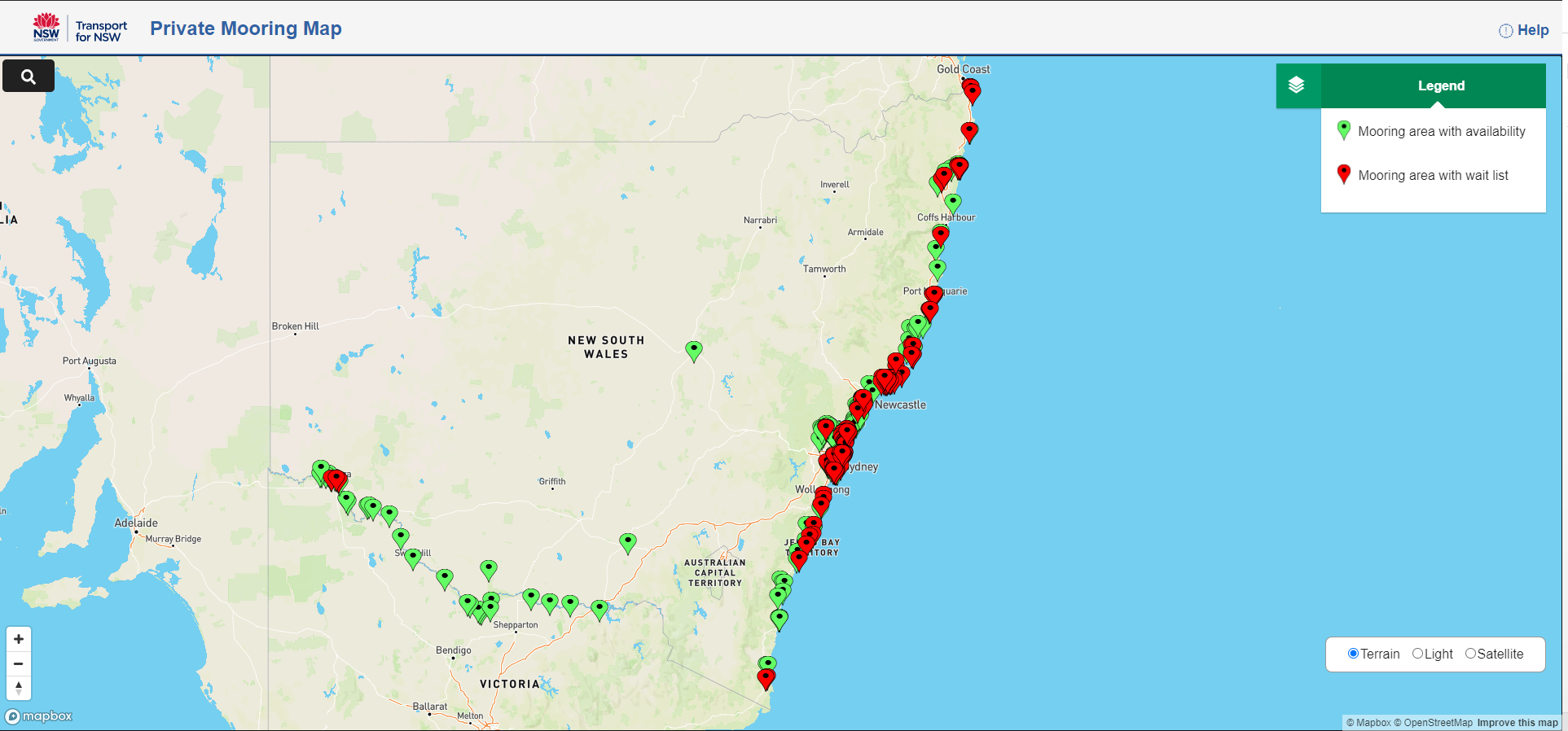
Operator contact details and location facilities for train stations, ferry wharves and bus interchanges. Gateway API is provided for legacy applications, this data is no longer updated and API will be retired in the the near future. To use these resources in your application please follow the CKAN api instructions in the resource description.
Document discussing the amount and location of oil in Tennessee: The Bureau of Land Management’s Jackson Field Office is located in Jackson, Mississippi, and is responsible for 11 southern states: Alabama, Arkansas, Florida, Georgia, Kentucky, Louisiana, Mississippi, North Carolina, South Carolina, Tennessee, and Virginia. The Jackson Field Office manages approximately 34.25 million acres of federal mineral estate in the eastern portion of the United State. Of this approximately 1.9 million mineral estate acres are located in Tennessee. The Reasonable Foreseeable Development Scenario (RFDS) forecasts fluid mineral exploration, development, and production for the planning area for the next 10 years. The RFDS assumes a baseline scenario in which no new policies are introduced and all areas not currently closed to leasing and development are opened for oil and gas activity.
This submission contains 167 deviatoric moment tensor (MT) solutions for the seismicity observed two years prior and three years post start of injection activities at The Geysers Prati 32 EGS Demonstration. Also included is a statistical representation of the properties of 751 fractures derived from the analysis of seismicity observed two years prior and three years post start of injection activities at The Geysers Prati 32 EGS Demonstration Project. The locations of the fractures are taken from microseismic hypocenters, the fracture areas are derived from moment magnitudes via scaling relationships, and the azimuths (sigma 1) and dips (sigma 3) are derived from the results of stress analyses.
Location of seismic lines carried out under DOE funded project Advanced Seismic Data Analysis Program (The Hot Pot Project). ArcGIS map package containing topographic base map, Township and Range layer, Oski BLM and private leases at time of survey, and locations, with selected shot points, of the five seismic lines.
Seismic Line Location Map Hot Pot Project, Humboldt County, Nevada 2010. Detailed map (pdf) showing topographic base map, Township and Range layer, Oski BLM and private leases at time of survey, and locations, with selected shot points, of the five seismic lines.
The site characterization data used to develop the conceptual geologic model for the Snake River Plain site in Idaho, as part of phase 1 of the Frontier Observatory for Research in Geothermal Energy (FORGE) initiative. This collection includes data on seismic events, groundwater, geomechanical models, gravity surveys, magnetics, resistivity, magnetotellurics (MT), rock physics, stress, the geologic setting, and supporting documentation, including several papers. Also included are 3D models (Petrel and Jewelsuite) of the proposed site. Data for wells INEL-1, WO-2, and USGS-142 have been included as links to separate data collections. These data have been assembled by the Snake River Geothermal Consortium (SRGC), a team of collaborators that includes members from national laboratories, universities, industry, and federal agencies, lead by the Idaho National Laboratory (INL). Other contributors include the National Renewable Energy Laboratory (NREL), Lawrence Livermore National Laboratory (LLNL), the Center for Advanced Energy Studies (CEAS), the University of Idaho, Idaho State University, Boise State University, University of Wyoming, University of Oklahoma, Energy and Geoscience Institute-University of Utah, US Geothermal, Baker Hughes Campbell Scientific Inc., Chena Power, US Geological Survey (USGS), Idaho Department of Water Resources, Idaho Geological Survey, and Mink GeoHydro.
Street lighting is a vital community asset that helps our community feel safer and more secure. Ausgrid maintains streetlights within our network area on behalf of local councils across Sydney, the Central Coast and the Hunter. This dataset contains locations for 1509 street light locations. For a searchable map of their locations please visit [https://www.ausgrid.com.au/In-your-community/Our-services/Streetlights#!/map.](https://www.ausgrid.com.au/In-your-community/Our-services/Streetlights#!/map)
The NSW Taxi Council is the peak body for the NSW Taxi Industry. It represents taxi networks, owners and operators. This dataset includes location points of the Taxi Ranks in the Sydney Metro area including 15 of the 23 Secure Taxi Ranks. Secure taxi ranks operate late on Friday and Saturday nights in busy locations across NSW. Security guards are on duty to help ensure a safe environment for both customers and drivers. The dataset is as at 31/10/2018, and includes decommissioned Taxi Ranks due to the implementation of the L2 and L3 Light Rail infrastructure and various Pop Up Cycleways, and is missing newly implemented Secure taxi ranks.
This dataset contains the location of the traffic lights in New South Wales.
Travel Zones (TZs) are the spatial unit of geography defined by Transport Performance and Analytics (TPA), a business unit within Transport for NSW (TfNSW). The TZ spatial layer is applied to data sources used by TfNSW for transport modelling and analysis, including the Household Travel Survey and the Census 2016 Journey to Work data. The Australian Bureau of Statistics (ABS) Statistical Area boundaries form the foundation of the TZ. Generally, a TZ is larger than a Statistical Area Level 1 or Mesh Block, both ABS geography definitions. The ABS Statistical Areas are based on population counts whereas TZ boundaries are defined using population, employment, housing and transport infrastructure. TZs are designed to have standardised trip generation levels across all zones. This causes zones to be different sizes across the metropolitan area. As with many other spatial boundaries, TZs tend to be small in areas with high land-use densities and larger in areas of lower density. This dataset now includes a CSV file mapping the Transit Stop Number (TSN) to the Travel Zone (TZ16). It captures the stop name, suburb and coordinates. [Travel Zone Explorer](https://www.transport.nsw.gov.au/data-and-research/reference-information/travel-zone-explorer-visualisation) is an interactive map where you can search for Travel Zones (TZ) and find out the current and future population in occupied private dwellings by age and sex.
A series of oscillatory pumping tests were performed at the BHRS. The data collected from these wells will be used to tomographically image the shallow subsurface. This excel file only contains well coordinates for all wells at the Boise site.
This submission includes two modeled drawdown scenarios with new supply well locations, a total dissolved solids (TDS) concentration grid (raster dataset representing the spatial distribution of TDS), and an excel spreadsheet containing well data.
This is the Utah FORGE well 16A(78)-32 stimulation microseismic detection and location report from Silixa LLC. The stimulation was accomplished during April, 2022.
Newberry seeks to explore "blind" (no surface evidence) convective hydrothermal systems associated with a young silicic pluton on the flanks of Newberry Volcano. This project will employ a combination of innovative and conventional techniques to identify the location of subsurface geothermal fluids associated with the hot pluton. Newberry project drill site location map 2010. This submission contains a topographic drill site location map.
Welcome to the Department of Ecology Well Logs. A Well Log means a Well Report and describes the location, ownership, construction details and lithology of a completed well. This web site enables you to search for wells which have well reports and to view the well report using a variety of search tools.
Wessex Water has over 400 water recycling centers (WRC's) across our region. This dataset contains key geographic information about: site location and the water catchment it is situated in, and the geographic area it serves
This data includes the locations of the MT data collected in and around the Coso Geothermal field that covered the West Flank area. These are the data that the 3D MT models were created from that were discussed in Phase 1 of the West Flank FORGE project. The projected coordinate system is NAD 1927 State Plane California IV FIPS 0404 and the Projection is Lambert Conformal Conic. Units are in feet.
Wild Nephin National Park is Ireland’s sixth National Park and located on the Western seaboard in northwest Mayo. It comprises of circa 15,000 hectares of Atlantic blanket bog and mountainous terrain, covering a vast uninhabited and unspoilt wilderness dominated by the Nephin Beg mountain range. To the west of the mountains is the Owenduff bog. This is one of the last intact active blanket bog systems in Ireland and Western Europe and is an important scientific and scenic feature of the National Park. Wild Nephin National Park is part of the Natura 2000 Network, which protects rare and important habitats and species under the EU Habitats and Birds Directive. This boundary map is for illustrative purposes only and shall not be held conclusive as to the boundaries or their extent. Please note the Department of Housing Local Government and Heritage makes no representation or provides any warranty as to the accuracy, completeness or currency of this map. The use of this map, which may be altered or updated at any time without notice, is at the sole risk of the user. https://www.nationalparks.ie/